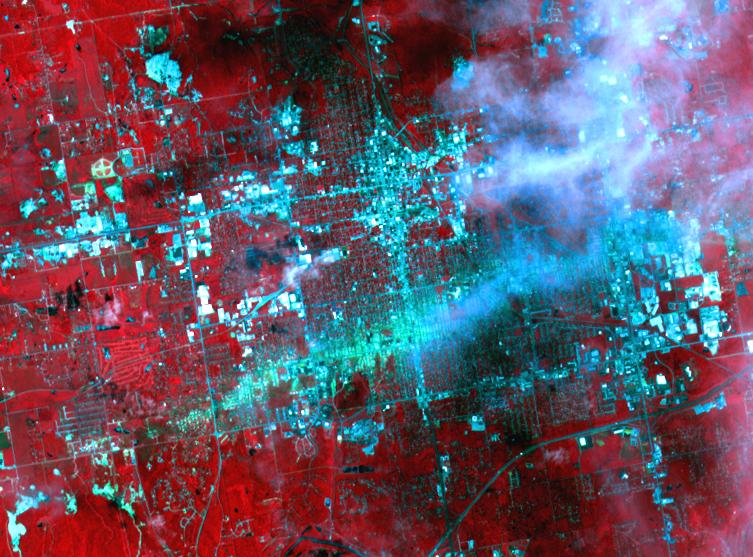
On May 30, 2011, a week after an EF-5 tornado swept through the city of Joplin, Mo, the Advanced Spaceborne Thermal Emission and Reflection Radiometer (ASTER) instrument on NASA's Terra spacecraft captured this image showing the track of the deadly tornado through the city. An estimated 30 percent of the city was damaged or destroyed by the 200-mile (322-kilometer) per hour winds, and more than 120 people lost their lives. On the image, vegetation is displayed in bright red, buildings are blue-cyan in color, and the track of the tornado appears as a green-blue track running horizontally across the image from the lower left to right center. Some thin clouds in white and their shadows are seen on the right side of the image. The image covers an area of 5.2 by 7 miles (8.4 by 11.3 kilometers) and is located at 37.1 degrees north latitude, 94.5 degrees west longitude.
With its 14 spectral bands from the visible to the thermal infrared wavelength region and its high spatial resolution of 15 to 90 meters (about 50 to 300 feet), ASTER images Earth to map and monitor the changing surface of our planet. ASTER is one of five Earth-observing instruments launched Dec. 18, 1999, on Terra. The instrument was built by Japan's Ministry of Economy, Trade and Industry. A joint U.S./Japan science team is responsible for validation and calibration of the instrument and data products.
The broad spectral coverage and high spectral resolution of ASTER provides scientists in numerous disciplines with critical information for surface mapping and monitoring of dynamic conditions and temporal change. Example applications are: monitoring glacial advances and retreats; monitoring potentially active volcanoes; identifying crop stress; determining cloud morphology and physical properties; wetlands evaluation; thermal pollution monitoring; coral reef degradation; surface temperature mapping of soils and geology; and measuring surface heat balance.
The U.S. science team is located at NASA's Jet Propulsion Laboratory, Pasadena, Calif. The Terra mission is part of NASA's Science Mission Directorate, Washington, D.C.
More information about ASTER is available at http://asterweb.jpl.nasa.gov/.
