Figure 1
Click on the image for larger versionGrímsvötn, the most active of Iceland's volcanoes, began erupting around 5:30 p.m. local time (1730 UTC) on Saturday, May 21, 2011. The volcano, located approximately 140 miles (220 kilometers) east of the capital city of Reykjavik, is situated beneath the Vatnajökull ice cap and last erupted in 2004. According to the Icelandic Meteorological Office, the recent eruption produced a plume that rose to a maximum altitude of approximately 66,000 feet (20 kilometers) on Saturday evening. As of Monday morning (May 23, 2011), plume heights were reported to range between 33,000 to 50,000 feet (10 to 15 kilometers). Iceland's Kevlavik airport was closed over the weekend, and a windblown cloud of ash has caused the cancellation of several airline flights over Scotland. Britain's Civil Aviation Authority reports that other parts of the United Kingdom and Ireland might be affected later in the week.
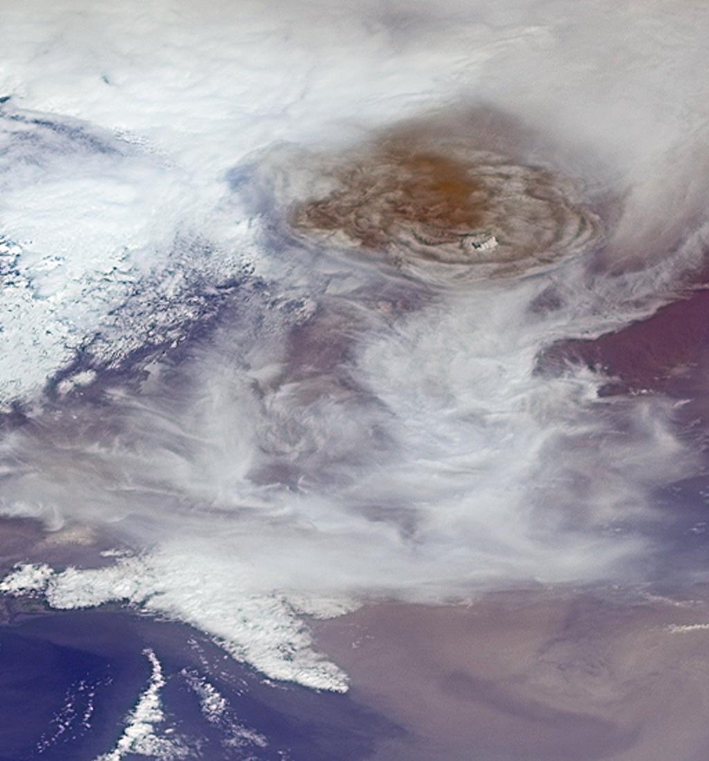
These images from the Multi-angle Imaging SpectroRadiometer (MISR) instrument on NASA's Terra spacecraft were captured during an overpass of the erupting volcano at 1:00 p.m. local time (1300 UTC) on Sunday May 22, 2011. The first image is a perspective view obtained by MISR's backward (northward) viewing camera that points at an angle of 60 degrees from the vertical. The image is about 88 miles (141 kilometers) wide. The large dome-shaped top of the eruption plume is located above the image center, and measures about 40 miles (65 kilometers) across. The plume stands out dramatically from the surrounding, lower clouds due to its reddish-brown color.The atmospheric winds near the plume were relatively weak, so the plume is rising almost vertically. A small bank of white clouds located at slightly higher altitude than the plume may be seen to be casting shadows on the ash below.
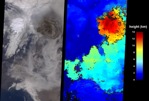
The second image (Figure 1), consisting of two panels, shows the more traditional nadir (vertically-oriented) camera view of the eruption at left, and a stereoscopic height analysis at right, generated by processing data from multiple MISR camera angles. The color scale shows the derived heights. This analysis places the maximum height of the plume at the time of overpass at about 46,000 feet (14 kilometers), which means that the ash has been injected into the stratosphere, the stratified portion of Earth's upper atmosphere. On this date, atmospheric soundings indicated that the boundary between the lower atmosphere, known as the troposphere, and the stratosphere was at an altitude of about 30,000 feet (9 kilometers).The neighboring wispy cirrus clouds that are visible in the scene occur at roughly this altitude. Near the lower right portion of the image, a diffuse ash cloud is also visible, with heights much closer to the surface.
MISR was built and is managed by NASA's Jet Propulsion Laboratory, Pasadena, Calif., for NASA's Science Mission Directorate, Washington, D.C. The Terra satellite is managed by NASA's Goddard Space Flight Center, Greenbelt, Md. The MISR data were obtained from the NASA Langley Research Center Atmospheric Science Data Center. JPL is a division of the California Institute of Technology.
 Planetary Data System


