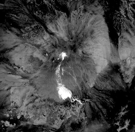
The high, isolated massif of Shiveluch volcano forms one of the largest and most active volcanoes in Russia's Kamchatka Peninsula. At least 60 large eruptions of Shiveluch have occurred during the last 10,000 years, making it the most vigorous volcano of the Kuril-Kamchatka volcanic arc. In this Jan. 25, 2011, nighttime thermal infrared image from the Advanced Spaceborne Thermal Emission and Reflection Radiometer (ASTER) instrument on NASA's Terra spacecraft, the bright, hot summit lava dome is evident in the center of the image. The hot trail of material descending to the south forms a large distributed deposit, indicating a recent collapse of the lava dome and formation of a large debris avalanche. The colder flat areas around the volcano appear in dark gray and black tones. The image covers an area of 6.7 by 6.7 kilometers (4.2 by 4.2 miles), and is located at 56.6 degrees north latitude, 161.3 degrees east longitude. The resolution of ASTER's thermal bands is 90 meters (about 300 feet).
With its 14 spectral bands from the visible to the thermal infrared wavelength region and its high spatial resolution of 15 to 90 meters (about 50 to 300 feet), ASTER images Earth to map and monitor the changing surface of our planet. ASTER is one of five Earth-observing instruments launched Dec. 18, 1999, on Terra. The instrument was built by Japan's Ministry of Economy, Trade and Industry. A joint U.S./Japan science team is responsible for validation and calibration of the instrument and data products.
The broad spectral coverage and high spectral resolution of ASTER provides scientists in numerous disciplines with critical information for surface mapping and monitoring of dynamic conditions and temporal change. Example applications are: monitoring glacial advances and retreats; monitoring potentially active volcanoes; identifying crop stress; determining cloud morphology and physical properties; wetlands evaluation; thermal pollution monitoring; coral reef degradation; surface temperature mapping of soils and geology; and measuring surface heat balance.
The U.S. science team is located at NASA's Jet Propulsion Laboratory, Pasadena, Calif. The Terra mission is part of NASA's Science Mission Directorate, Washington, D.C.
More information about ASTER is available at http://asterweb.jpl.nasa.gov/.