Welcome back to another chance to play geographical detective! MISR is proud to be re-introducing these quizzes on a periodic basis.
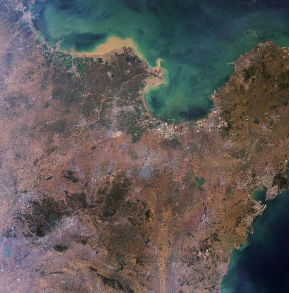
This image was acquired by the Multi-angle Imaging SpectroRadiometer (MISR) and represents an area of about 368 kilometers and 373 kilometers. North is at the top. Most of the landmass falls within a named geographic region. This region is defined by its political boundaries within a larger country, and may be a state, a province, a department, or similar entity. These questions refer to this geographic region. You may use any reference materials you like to answer them.
From the statements below, please indicate which ones are True or False:
1. Although rich in many natural resources, excessive mining during the previous century has nearly depleted the natural supply of gold in this region.
Answer: FALSE
The gold mines remained largely unexplored, until government reforms and foreign investments allowed for operational growth and expansion. In fact, production has increased so quickly during the last decade that in 2007, the Shangdong province of China surpassed South Africa as the leading producer of gold in the world.
2. Within the mountainous area in the southwest quadrant of this image is a location noted for religious worship that has continued for several millennia.
Answer: TRUE
Mount Tai, near the city of Tai'an is one of the five sacred mountains to Buddhists and Taoists. As the Eastern mountain, Mount Tai or Tai Shan means, Tranquil Mountain in Chinese and symbolizes sunrise, birth and renewal. Religious worship at the mountain has been continuing for over 3,000 years, including by China's first emperor, Qin Shi Huang.
3. Sedimentation and industrial pollution in the river whose outlet is near the top of the image has dampened the economy of this region due to the resulting dramatic reduction in shipping.
Answer: FALSE
The Yellow River or Huang He, is the second longest river in China. The river is named for coloration from the silt carried from the Loess Plateau. Industry dumping and sewage have heavily polluted the river, over 1/3 being unusable for agriculture and industrial use. However, the river flows into the Bohai Sea, one of the busiest seaports of China, and the province is ranked 3rd in GDP for China.
4. The name of one of the major cities in this region -- also the name of a brand of beer -- evokes a verdant locale; a nearby winery is noted for its prize-winning Chardonnay.
Answer: TRUE
Qingdao (Wade-Giles pronunciation or Tsingtao for the postal spelling) means green or lush island in Chinese. The name stands for both the city, and the name of the beer and brewery that was started when the province was under German rule. Although Qingdao is famous for its beer, the nearby Huadong Winery, founded in the mid 1980's, produces a number of European variety white and red wines, and has won several awards in international wine contests.
5. Rapid population development, as seen in the rim areas, has resulted in the proliferation of Phragmites australis, raising international concerns over the deterioration of the local ecosystem.
Answer: FALSE
The Bohai Sea saline meadows are located in the upper reaches of the Yellow Sea to the west of the Shandong Peninsula. Grass and sedge marshes are important to the freshwater lakeside ecosystem further inland, but these have been almost completely destroyed by rice agriculture and fish aquaculture, as have the native reed beds of Phragmites australis.
6. The delta mouth formed by the large sediment-laden river in the image is an example of a well preserved wetland ecosystem, and is used as a "transfer station" for millions of migrating birds, including several rare species.
Answer: TRUE
The Yellow River Delta region in the Shangdong province serves as a stopover for a variety of species of birds including such rarities as the red-crowned crane (Grus japonensis) and the Siberian crane (G. leucogeranus). The rare Saunders' gull (Larus saundersi), listed as vulnerable by IUCN and BirdLife International, uses the Huang He or Yellow River Delta as one of its four global breeding sites.
7. A city located within the pictured region is the site of a major oilfield and is one of the world's leading producers of rubber tires.
Answer: TRUE
The city of Dongying, located along the western coast of Laizhou Bay, is home to the Shengli Oilfield, the second largest in China. Oil and gas have played major roles in the city's economic development. The city is home to many rubber tire factories, and houses a campus of the China University of Petroleum.
MISR was built and is managed by NASA's Jet Propulsion Laboratory, Pasadena, CA, for NASA's Office of Earth Science, Washington, DC. The Terra satellite is managed by NASA's Goddard Space Flight Center, Greenbelt, MD. JPL is a division of the California Institute of Technology.