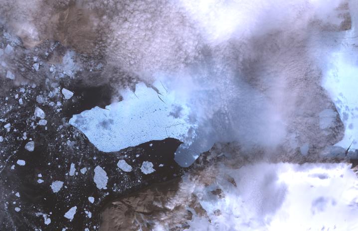
On Aug. 5, 2010, an enormous chunk of ice, roughly 251 square kilometers (97 square miles) in size, broke off the Petermann Glacier along the northwestern coast of Greenland. The Petermann Glacier lost about one-quarter of its 70-kilometer- (40-mile-) long floating ice shelf, according to researchers at the University of Delaware. The recently calved iceberg is the largest to form in the Arctic in 50 years.
Icebergs calving off the Petermann Glacier are not unusual. Petermann Glacier's floating ice tongue is the Northern Hemisphere's largest, and it has occasionally calved large icebergs.
Scientists are monitoring the movement of the iceberg closely. If it moves out into the narrow Nares Strait, there is the potential it could interfere with or block the loss of Arctic sea ice out of the Arctic Ocean into Baffin Bay, a sea that connects the Arctic and Atlantic Oceans.
This image of Petermann Glacier and the new iceberg was acquired from the Advanced Spaceborne Thermal Emission and Reflection Radiometer (ASTER) instrument on NASA's Terra spacecraft on Aug. 12, 2010. It covers an area of 49.5 by 31.5 kilometers (30.7 by 19.5 miles) and is located at 81.1 degrees north latitude, 61.7 degrees west longitude.
With its 14 spectral bands from the visible to the thermal infrared wavelength region and its high spatial resolution of 15 to 90 meters (about 50 to 300 feet), ASTER images Earth to map and monitor the changing surface of our planet. ASTER is one of five Earth-observing instruments launched Dec. 18, 1999, on NASA's Terra spacecraft. The instrument was built by Japan's Ministry of Economy, Trade and Industry. A joint U.S./Japan science team is responsible for validation and calibration of the instrument and the data products.
The broad spectral coverage and high spectral resolution of ASTER provides scientists in numerous disciplines with critical information for surface mapping and monitoring of dynamic conditions and temporal change. Example applications are: monitoring glacial advances and retreats; monitoring potentially active volcanoes; identifying crop stress; determining cloud morphology and physical properties; wetlands evaluation; thermal pollution monitoring; coral reef degradation; surface temperature mapping of soils and geology; and measuring surface heat balance.
The ASTER U.S. science team is located at NASA's Jet Propulsion Laboratory, Pasadena, Calif. The Terra mission is part of NASA's Science Mission Directorate, Washington, D.C.
More information about ASTER is available at http://asterweb.jpl.nasa.gov/.
 Planetary Data System


