PDS logoPlanetary Data System
PDS Information
Find a Node - Use these links to navigate to any of the 8 publicly accessible PDS Nodes.

This bar indicates that you are within the PDS enterprise which includes 6 science discipline nodes and 2 support nodes which are overseen by the Project Management Office at NASA's Goddard Space Flight Center (GSFC). Each node is led by an expert in the subject discipline, supported by an advisory group of other practitioners of that discipline, and subject to selection and approval under a regular NASA Research Announcement.
Click here to return to the Photojournal Home Page Click here to view a list of Photojournal Image Galleries Photojournal_inner_header
Latest Images  |  Spacecraft & Technology  |  Animations  |  Space Images App  |  Feedback  |  Photojournal Search  

PIA13155: Birth of a Loop Current Eddy
 Target Name:  Earth
 Is a satellite of:  Sol (our sun)
 Mission:  OSTM/Jason-2
 Spacecraft:  OSTM/Jason-2
 Instrument:  Altimeter 
 Product Size:  612 x 627 pixels (w x h)
 Produced By:  University of Colorado 
 Other  
Information: 
JPL News Release 2010-178
 Full-Res TIFF:  PIA13155.tif (385.9 kB)
 Full-Res JPEG:  PIA13155.jpg (69.75 kB)

Click on the image above to download a moderately sized image in JPEG format (possibly reduced in size from original)

Original Caption Released with Image:

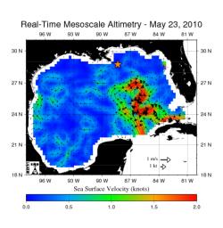
The northern portion of the Gulf of Mexico's Loop Current, shown in red, appears about to detach a large ring of current, creating a separate eddy. An eddy is a large, warm, clockwise-spinning vortex of water -- the ocean's version of a cyclone. This image, created with measurements of sea surface height from multiple satellites, including the NASA/French Space Agency Jason-1 and Ocean Surface Topography Mission/Jason-2 satellites, shows the speed and direction of surface currents in the Gulf. The star shows the former location of the Deepwater Horizon, the drilling rig that exploded and sank in April, and has been leaking oil since. A large eddy between the leak and the Loop Current might keep, at least temporarily, some of the spilling oil from reaching the Florida Straits, the ocean channel between the Florida Keys and Cuba, and being transported to the east coast of Florida and northward into the Gulf Stream.

This map was produced by the Colorado Center for Astrodynamics Research in Boulder, Colo. The center processes satellite measurements of sea surface height in near real-time to create maps of the Gulf of Mexico, showing the location of medium-sized eddies and fronts. More information on these data products is available at http://argo.colorado.edu/~realtime/welcome/ .

For more information on NASA's ocean surface topography missions, see http://sealevel.jpl.nasa.gov/ or to view the latest Jason data see http://sealevel.jpl.nasa.gov/science/jason1-quick-look/.

Image Credit:
NASA/JPL/University of Colorado

Image Addition Date:
2010-05-24