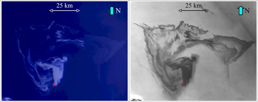
Figure 1
Click on the image for larger versionOn April 22, 2010, the Deepwater Horizon oil platform in the Gulf of Mexico sank in nearly 1,500 meters (4,900 feet) of water after an explosion that took place on April 20. This accident resulted in a significant oil spill from the well nearly a mile below the ocean surface.
The Multi-angle Imaging SpectroRadiometer (MISR) instrument on NASA's Terra satellite acquired these images on May 1, 2010, at approximately 11:44 a.m. local time (16:44 UTC).
The image on the left (Figure 1) is an enhanced "true color" view of the oil slick at 275 meters (902 feet) resolution from MISR's nadir (downward)-viewing camera. The image is centered on 88.26 degrees west, 29.12 degrees north, about 200 kilometers (656,168 feet) southeast of New Orleans, La. The image dimensions are about 120 kilometers (393,701 feet) in the east-west direction and 150 kilometers (492,126 feet) in the north-south direction. The red symbol indicates the approximate position of the Deepwater Horizon platform and the source of the oil slick. Oil is lighter than water and will float on top of the water surface, suppressing small waves and changing the way the surface reflects light. This change in the reflection of sunlight makes the oil slick appear lighter blue on the darker blue waters of the Gulf of Mexico. Some clouds are visible in the extreme lower left corner of the image.
The image on the right (Figure 1) is a multiangle composite image of the oil spill, showing the ratio between the reflectances of the 26.1 degree aftward viewing (Aa) camera and the 26.1 degree forward viewing (Af) camera. The Af camera sees the reflection of sunlight from the oil more strongly than the Aa camera, so this ratio makes the oil slick appear dark gray. The uncontaminated water appears much lighter. This composite image reveals finer detail of the oil on the surface than can be seen from the nadir-viewing camera alone. Darker regions indicate higher concentrations of oil on the surface. This image also shows more clearly the large concentration of oil emanating from the source. The large area on the right-hand side of the image reveals the broad extent of the slick to the east where the oil sheet appears much fainter in the nadir color image. Careful examination of the image also reveals thin streaks running from northwest to southeast that terminate at a point. These correspond to boats that are assisting with the cleanup effort.
The sensitivity of MISR's multiangle imaging to the presence of the oil allows the size of the visible slick to be estimated at about 3,800 square kilometers (1,500 square miles) on this date, which is larger than the state of Rhode Island.
MISR was built and is managed by NASA's Jet Propulsion Laboratory, Pasadena, Calif., for NASA's Science Mission Directorate, Washington, D.C. The Terra satellite is managed by NASA's Goddard Space Flight Center, Greenbelt, Md. The MISR data were obtained from the NASA Langley Research Center Atmospheric Science Data Center. JPL is a division of the California Institute of Technology.
