The Advanced Spaceborne Thermal Emission and Reflection Radiometer (ASTER) instrument on NASA's Terra spacecraft captured this pair of images of the growing oil spill in the Gulf of Mexico on May 1, 2010. On April 20, 2010, an explosion destroyed the Deepwater Horizon oil platform operating in the Gulf of Mexico 80 kilometers (50 miles) offshore, resulting in substantial loss of life and releasing 5,000 barrels of oil per day into the water. The huge oil slick was being carried towards the Mississippi River Delta, and was expected to reach the Louisiana, Alabama, and Mississippi shores as early as Mon., May 3.
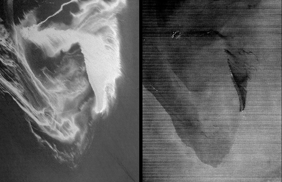
This ASTER image is located at 29.0 degrees north latitude, 88.3 degrees west longitude and covers an area measuring 41.8 by 54.6 kilometers (25.9 by 33.8 miles), about 32 kilometers (20 miles) west of the mouth of the Mississippi River delta. No land is visible in the image. In the left image, acquired in the visible part of the spectrum, the varying shades of white reflect different thicknesses of oil. The source of the oil spill is visible as the bright white area in the bottom center of the image. The thickest part of the oil spill extends vertically from it, appearing somewhat like the ash plume of an erupting volcano. The wispy patterns of the oil spill reflect the transport of the oil by waves and currents.
The right image is a thermal picture of the same area, with the coldest surfaces appearing dark, and the warmest appearing white. Only the thickest parts of the oil slick are colder than the ocean water temperature. In the upper left, bright spots are fires where attempts have been made to burn the slick. Large dark-light patterns are ocean currents that concentrate and disperse the oil plume.
With its 14 spectral bands from the visible to the thermal infrared wavelength region and its high spatial resolution of 15 to 90 meters (about 50 to 300 feet), ASTER images Earth to map and monitor the changing surface of our planet. ASTER is one of five Earth-observing instruments launched December 18, 1999, on NASA's Terra. The instrument was built by Japan's Ministry of Economy, Trade and Industry. A joint U.S./Japan science team is responsible for validation and calibration of the instrument and the data products. The broad spectral coverage and high spectral resolution of ASTER provides scientists in numerous disciplines with critical information for surface mapping and monitoring of dynamic conditions and temporal change. Example applications are: monitoring glacial advances and retreats; monitoring potentially active volcanoes; identifying crop stress; determining cloud morphology and physical properties; wetlands evaluation; thermal pollution monitoring; coral reef degradation; surface temperature mapping of soils and geology; and measuring surface heat balance.
The ASTER U.S. science team is located at NASA's Jet Propulsion Laboratory, Pasadena, Calif. The Terra mission is part of NASA's Science Mission Directorate, Washington, D.C.
More information about ASTER is available at http://asterweb.jpl.nasa.gov/.
