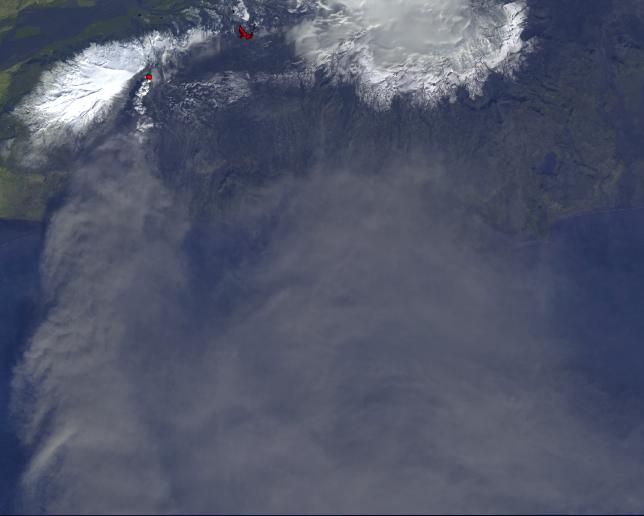
On Monday, April 19, 2010, the Advanced Spaceborne Thermal Emission and Reflection Radiometer (ASTER) instrument onboard NASA's Terra spacecraft obtained this image of the continuing eruption of Iceland's Eyjafjallajökull volcano. The image shows a white eruption column being transported to the south by the prevailing winds. The image is dominated by the gray, ash-laden eruption cloud dispersed south and east by the winds, blowing from the southern Iceland coast towards Europe. The bright red areas mark the hot lava at the present vent, and the still-hot lava flows from the earlier phases of the eruption. The high-temperature material is revealed by ASTER's thermal infrared bands. This image covers an area of 58.6 by 46.8 kilometers (36.3 by 29 miles). The resolution is 15 meters (49 feet) per pixel.
With its 14 spectral bands from the visible to the thermal infrared wavelength region and its high spatial resolution of 15 to 90 meters (about 50 to 300 feet), ASTER images Earth to map and monitor the changing surface of our planet. ASTER is one of five Earth-observing instruments launched December 18, 1999, on NASA's Terra. The instrument was built by Japan's Ministry of Economy, Trade and Industry. A joint U.S./Japan science team is responsible for validation and calibration of the instrument and the data products.
The broad spectral coverage and high spectral resolution of ASTER provides scientists in numerous disciplines with critical information for surface mapping and monitoring of dynamic conditions and temporal change. Example applications are: monitoring glacial advances and retreats; monitoring potentially active volcanoes; identifying crop stress; determining cloud morphology and physical properties; wetlands evaluation; thermal pollution monitoring; coral reef degradation; surface temperature mapping of soils and geology; and measuring surface heat balance.
The ASTER U.S. science team is located at NASA's Jet Propulsion Laboratory, Pasadena, Calif. The Terra mission is part of NASA's Science Mission Directorate, Washington, D.C.
More information about ASTER is available at http://asterweb.jpl.nasa.gov/.