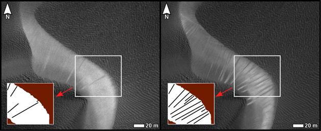
Before and after images from the High Resolution Imaging Science Experiment (HiRISE) camera on NASA's Mars Reconnaissance Orbiter illustrate occurrence of new streaks on the slip face of a dark sand dune in the Nili Patera region of Mars. The slip face is on a dune's downwind side.
The image on the left is from a June 30, 2007, observation (late autumn at the site). The one on the right is of the same ground observed 15 weeks later, on Oct. 13, 2007 (winter at the site). In each image, an inset box in the lower left holds a diagram of streaks discernible on the portion of the slip face within the inscribed box near the center of the image. The new streaks in the later image are interpreted as grainflow events, suggesting dune activity between late autumn and winter. White scale bars in each image are 20 meters (66 feet) long. North is toward the top.
A locator map at PIA12857 shows the context for the area shown in these images. The inset box there labeled 5a-a' indicates the location of this pair. The site is field of dark sand dunes at 9 degrees north latitude, 67 degrees east longitude.
This comparison is part of a study of whether wind-shaped bedforms on Mars -- dunes and ripples -- are actively migrating in present-day atmospheric conditions. It is from a presentation by S. Silvestro, L.K. Fenton and D.A. Vaz at the 41st Lunar and Planetary Sciences Conference, March 2010, reporting that the bedforms at this Nili Patera site are actively migrating. The changes suggest that these dunes are not heavily cemented or crusted.
Other products from the June 30, 2007, HiRISE observation of this dune field are available at http://hirise.lpl.arizona.edu/PSP_004339_1890. Other products from Oct. 13, 2007, observation are available at http://hirise.lpl.arizona.edu/PSP_005684_1890.
The University of Arizona, Tucson, operates the HiRISE camera, which was built by Ball Aerospace & Technologies Corp., Boulder, Colo. NASA's Jet Propulsion Laboratory, a division of the California Institute of Technology, Pasadena, manages the Mars Reconnaissance Orbiter for the NASA Science Mission Directorate, Washington. Lockheed Martin Space Systems, Denver, is the spacecraft development and integration contractor for the project and built the spacecraft.
 Planetary Data System


