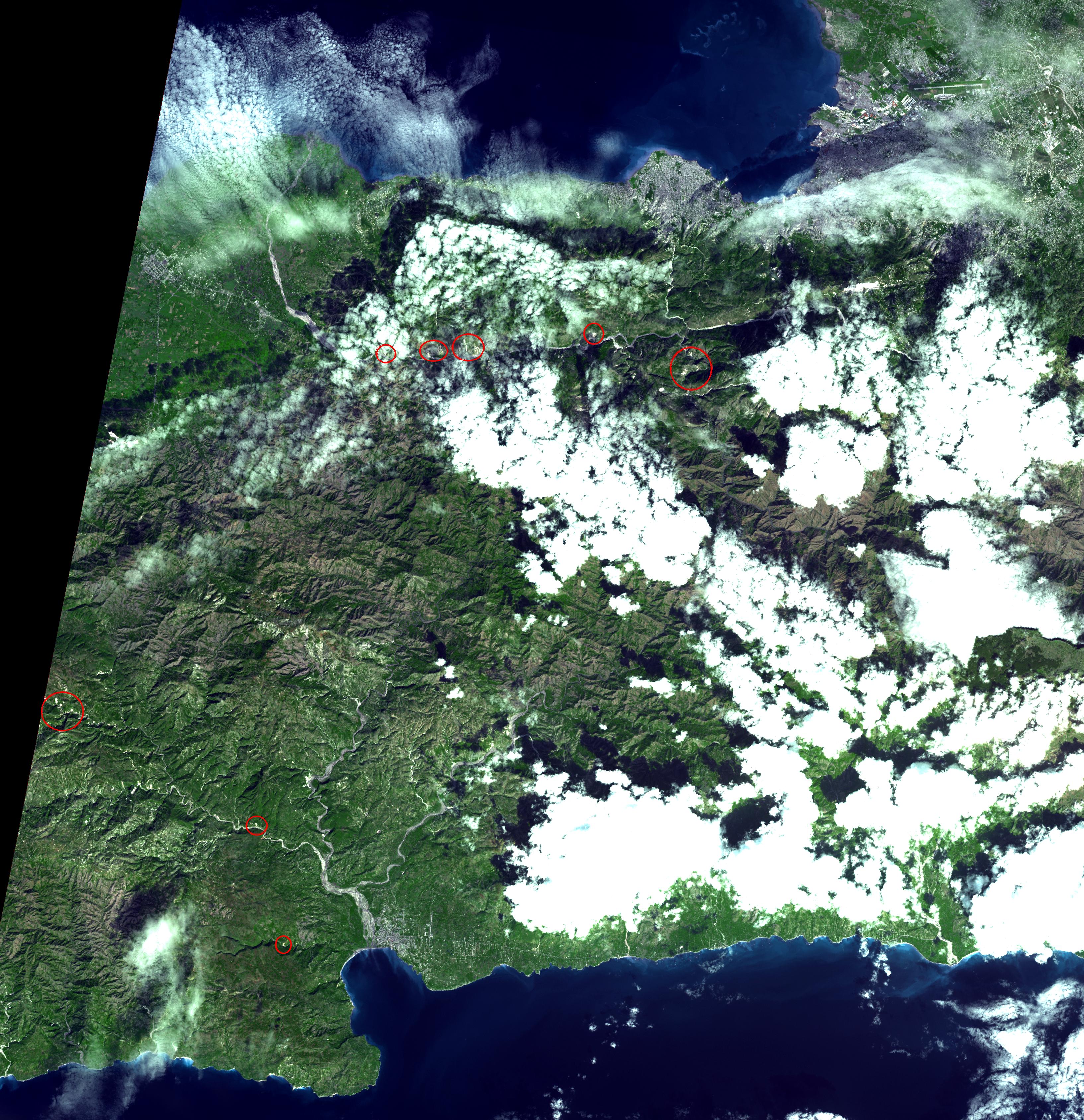
On January 14, 2010, the Advanced Spaceborne Thermal Emission and Reflection Radiometer (ASTER) instrument on NASA's Terra spacecraft captured this simulated natural color image of the Port-au-Prince, Haiti, area, two days after a magnitude 7.0 earthquake struck the region and caused massive damage and loss of life. While ASTER's 15-meter (50-foot) resolution is not sufficient to see damaged buildings, it can be used to identify other results of the shaking. The red circles superimposed on the image indicate possible landslides, a common occurrence in mountainous terrain after large earthquakes. The possible landslides were identified by carefully comparing the new image with an image acquired one year previously.
With its 14 spectral bands from the visible to the thermal infrared wavelength region and its high spatial resolution of 15 to 90 meters (about 50 to 300 feet), ASTER images Earth to map and monitor the changing surface of our planet. ASTER is one of five Earth-observing instruments launched December 18, 1999, on NASA's Terra satellite. The instrument was built by Japan's Ministry of Economy, Trade and Industry. A joint U.S./Japan science team is responsible for validation and calibration of the instrument and the data products.
The broad spectral coverage and high spectral resolution of ASTER provide scientists in numerous disciplines with critical information for surface mapping and monitoring of dynamic conditions and temporal change. Example applications include monitoring glacial advances and retreats; monitoring potentially active volcanoes; identifying crop stress; determining cloud morphology and physical properties; wetlands evaluation; thermal pollution monitoring; coral reef degradation; surface temperature mapping of soils and geology; and measuring surface heat balance.
The U.S. science team is located at NASA's Jet Propulsion Laboratory, Pasadena, Calif. The Terra mission is part of NASA's Science Mission Directorate, Washington, D.C.
More information about ASTER is available at http://asterweb.jpl.nasa.gov/.
Image acquired: January 14, 2010
Area covered: 50.6 by 49 kilometers (31.4 by 30.4 miles)
Location of image: 18.5 degrees North latitude, 72.5 degrees West longitude
Image resolution: 15 meters (50 feet)
 Planetary Data System


