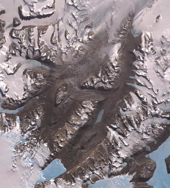
The McMurdo Dry Valleys are a row of valleys west of McMurdo Sound, Antarctica. They are so named because of their extremely low humidity and lack of snow and ice cover. Photosynthetic bacteria have been found living in the relatively moist interior of rocks. Scientists consider the Dry Valleys to be the closest of any terrestrial environment to Mars. Wright Valley extends across the image from lower left to upper right. To the left of it, and partially fog-covered, is Victoria Valley. The image was acquired December 8, 2002, covers an area of 58.5 x 64.9 km, and is located at 77.5 degrees south latitude, 162 degrees east longitude.
With its 14 spectral bands from the visible to the thermal infrared wavelength region and its high spatial resolution of 15 to 90 meters (about 50 to 300 feet), ASTER images Earth to map and monitor the changing surface of our planet. ASTER is one of five Earth-observing instruments launched December 18, 1999, on NASA's Terra satellite. The instrument was built by Japan's Ministry of Economy, Trade and Industry. A joint U.S./Japan science team is responsible for validation and calibration of the instrument and the data products.
The broad spectral coverage and high spectral resolution of ASTER provides scientists in numerous disciplines with critical information for surface mapping and monitoring of dynamic conditions and temporal change. Example applications are: monitoring glacial advances and retreats; monitoring potentially active volcanoes; identifying crop stress; determining cloud morphology and physical properties; wetlands evaluation; thermal pollution monitoring; coral reef degradation; surface temperature mapping of soils and geology; and measuring surface heat balance.
The U.S. science team is located at JPL, Pasadena, Calif. The Terra mission is part of NASA's Science Mission Directorate.
More information about ASTER is available at http://asterweb.jpl.nasa.gov/.