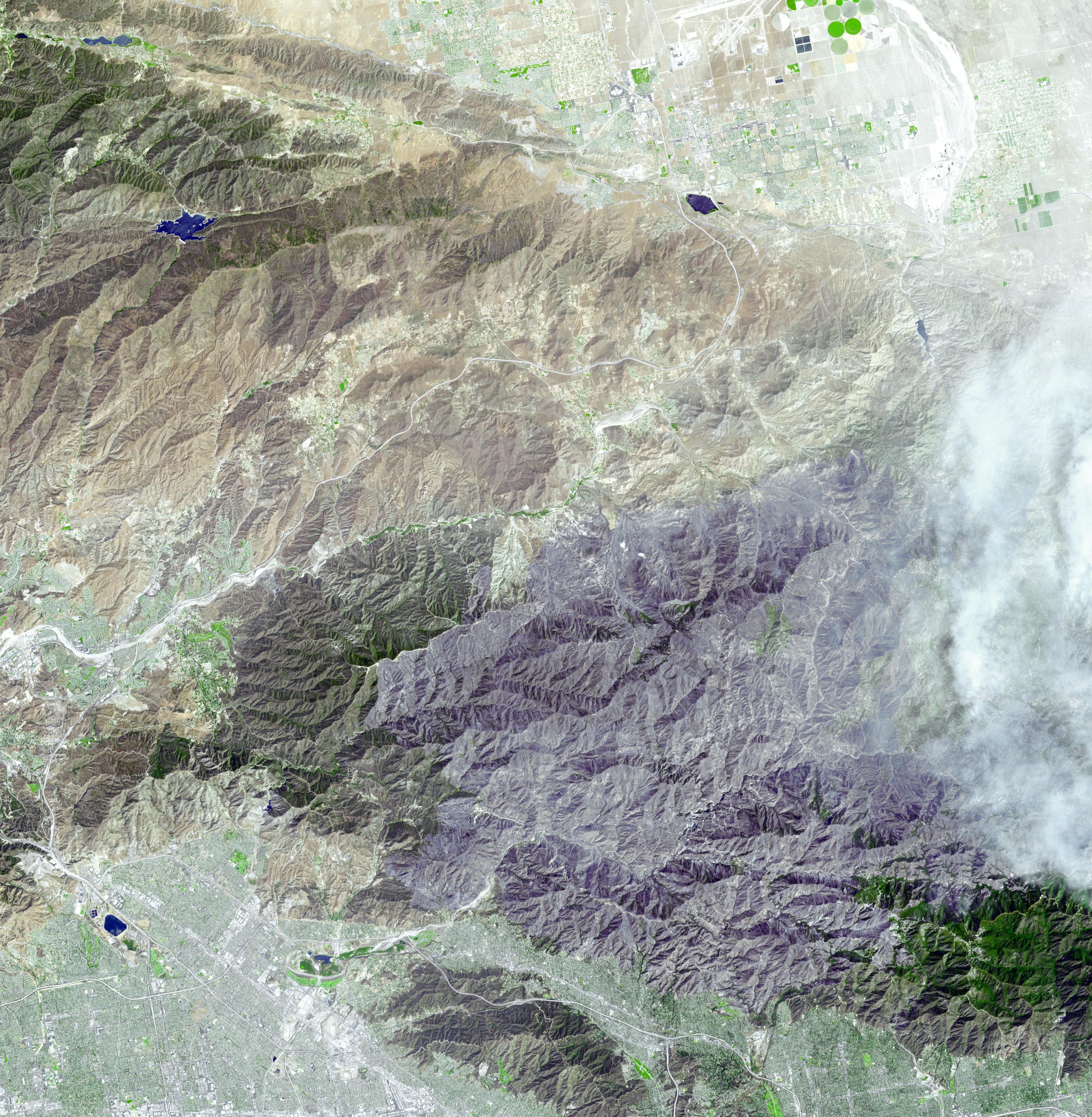
On September 6, 2009, the Advanced Spaceborne Thermal Emission and Reflection Radiometer (ASTER) instrument on NASA's Terra satellite captured this simulated natural color image of the Station fire, burning in the San Gabriel Mountains north of Los Angeles. The fire started on August 26 in La Canada/Flintridge near NASA's Jet Propulsion Laboratory in Pasadena (seen at the bottom of the image), and soon grew to become the largest fire in Los Angeles County's history. Ten days after its start, the fire had consumed more than 160,000 acres (251 square miles) of forest, leaving behind a charred, blackened landscape, as it spread eastward. Smoke from the actively burning area can be seen on the right side of the image; the large dark gray area dominating the image is the evidence of forest and chaparral destruction.
With its 14 spectral bands from the visible to the thermal infrared wavelength region and its high spatial resolution of 15 to 90 meters (about 50 to 300 feet), ASTER images Earth to map and monitor the changing surface of our planet. ASTER is one of five Earth-observing instruments launched December 18, 1999, on NASA's Terra satellite. The instrument was built by Japan's Ministry of Economy, Trade and Industry. A joint U.S./Japan science team is responsible for validation and calibration of the instrument and the data products.
The broad spectral coverage and high spectral resolution of ASTER provides scientists in numerous disciplines with critical information for surface mapping and monitoring of dynamic conditions and temporal change. Example applications are: monitoring glacial advances and retreats; monitoring potentially active volcanoes; identifying crop stress; determining cloud morphology and physical properties; wetlands evaluation; thermal pollution monitoring; coral reef degradation; surface temperature mapping of soils and geology; and measuring surface heat balance.
The U.S. science team is located at NASA's Jet Propulsion Laboratory, Pasadena, Calif. The Terra mission is part of NASA's Science Mission Directorate, Washington, D.C.
More information about ASTER is available at http://asterweb.jpl.nasa.gov/.
Image acquired: September 6, 2009
Area covered: 31.7 by 32.5 miles (51.2 by 52.4 kilometers)
Location of image: 34.3 degrees North latitude, 118.2 degrees West longitude
Image resolution: 50 feet (15 meters)
