PDS logoPlanetary Data System
PDS Information
Find a Node - Use these links to navigate to any of the 8 publicly accessible PDS Nodes.

This bar indicates that you are within the PDS enterprise which includes 6 science discipline nodes and 2 support nodes which are overseen by the Project Management Office at NASA's Goddard Space Flight Center (GSFC). Each node is led by an expert in the subject discipline, supported by an advisory group of other practitioners of that discipline, and subject to selection and approval under a regular NASA Research Announcement.
Click here to return to the Photojournal Home Page Click here to view a list of Photojournal Image Galleries Photojournal_inner_header
Latest Images  |  Spacecraft & Technology  |  Animations  |  Space Images App  |  Feedback  |  Photojournal Search  

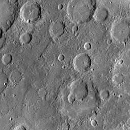
PIA12163: A Jumble of Impacts
 Target Name:  Mercury
 Is a satellite of:  Sol (our sun)
 Mission:  MESSENGER
 Spacecraft:  MESSENGER
 Instrument:  MDIS - Narrow Angle
 Product Size:  1018 x 1022 pixels (w x h)
 Produced By:  Johns Hopkins University/APL
 Full-Res TIFF:  PIA12163.tif (3.126 MB)
 Full-Res JPEG:  PIA12163.jpg (215.9 kB)

Click on the image above to download a moderately sized image in JPEG format (possibly reduced in size from original)

Original Caption Released with Image:

Click here for larger version of PIA12163
Click on the image for larger version

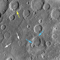
The craters in this NAC image display a variety of interesting characteristics. Visible in the lower half of this image (blue arrows in figure 1) are several overlapping impact craters. These craters have degraded walls, making it somewhat difficult to distinguish the boundaries between them. Several other craters in this image (white arrows) have only their rims visible, suggesting that they were flooded with volcanic lava (PIA10601). In contrast, the crater indicated by the yellow arrow preserves a set of central peaks (a common feature found in other craters including Amaral, see PIA11771), suggesting that it has been less altered than its flooded and degraded neighbors and likely formed more recently.

Date Acquired: October 6, 2008
Image Mission Elapsed Time (MET): 131772123
Instrument: Narrow Angle Camera (NAC) of the Mercury Dual Imaging System (MDIS)
Resolution: 280 meters/pixel (0.17 miles/pixel)
Scale: Image is about 285 kilometers (177 miles) across
Spacecraft Altitude: 10,900 kilometers (6,800 miles)

These images are from MESSENGER, a NASA Discovery mission to conduct the first orbital study of the innermost planet, Mercury. For information regarding the use of images, see the MESSENGER image use policy.

Image Credit:
NASA/Johns Hopkins University Applied Physics Laboratory/Carnegie Institution of Washington

Image Addition Date:
2009-08-04