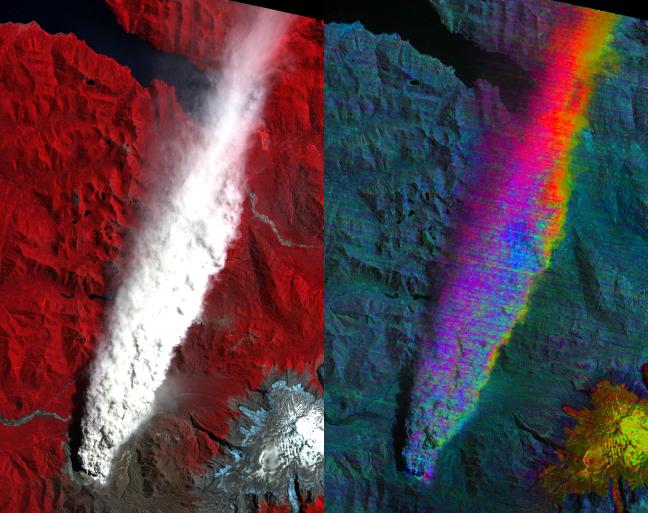
Chaiten Volcano, Chile continues to erupt after first exploding in May 2008 following about 9,000 years of inactivity. The left image is the visible-near infrared composite, with vegetation in red. You can clearly see the extent of the plume. The right image is a color stretch of the multispectral thermal infrared bands: red is ash-rich, yellow/orange is sulfur dioxide gas, and blue is water-rich. Only the edges and distal portions of the plume, where it's more transparent, show ash or SO2.
The image was acquired January 19, 2009, covers an area of 20.5 x 41 km, and is located near 42.8 degrees south latitude, 72.6 degrees west longitude.
With its 14 spectral bands from the visible to the thermal infrared wavelength region and its high spatial resolution of 15 to 90 meters (about 50 to 300 feet), ASTER images Earth to map and monitor the changing surface of our planet. ASTER is one of five Earth-observing instruments launched December 18, 1999, on NASA's Terra satellite. The instrument was built by Japan's Ministry of Economy, Trade and Industry. A joint U.S./Japan science team is responsible for validation and calibration of the instrument and the data products.
The broad spectral coverage and high spectral resolution of ASTER provides scientists in numerous disciplines with critical information for surface mapping and monitoring of dynamic conditions and temporal change. Example applications are: monitoring glacial advances and retreats; monitoring potentially active volcanoes; identifying crop stress; determining cloud morphology and physical properties; wetlands evaluation; thermal pollution monitoring; coral reef degradation; surface temperature mapping of soils and geology; and measuring surface heat balance.
The U.S. science team is located at NASA's Jet Propulsion Laboratory, Pasadena, Calif. The Terra mission is part of NASA's Science Mission Directorate.
More information about ASTER is available at http://asterweb.jpl.nasa.gov/.