PDS logoPlanetary Data System
PDS Information
Find a Node - Use these links to navigate to any of the 8 publicly accessible PDS Nodes.

This bar indicates that you are within the PDS enterprise which includes 6 science discipline nodes and 2 support nodes which are overseen by the Project Management Office at NASA's Goddard Space Flight Center (GSFC). Each node is led by an expert in the subject discipline, supported by an advisory group of other practitioners of that discipline, and subject to selection and approval under a regular NASA Research Announcement.
Click here to return to the Photojournal Home Page Click here to view a list of Photojournal Image Galleries Photojournal_inner_header
Latest Images  |  Spacecraft & Technology  |  Animations  |  Space Images App  |  Feedback  |  Photojournal Search  

PIA11727: NASA's Moon Mineralogy Mapper
 Target Name:  Moon
 Is a satellite of:  Earth
 Mission:  Chandrayaan-1
 Spacecraft:  Chandrayaan-1
 Instrument:  Moon Mineralogy Mapper
 Product Size:  631 x 635 pixels (w x h)
 Produced By:  JPL
 Full-Res TIFF:  PIA11727.tif (1.204 MB)
 Full-Res JPEG:  PIA11727.jpg (65.59 kB)

Click on the image above to download a moderately sized image in JPEG format (possibly reduced in size from original)

Original Caption Released with Image:

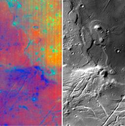
Different wavelengths of light provide new information about the Orientale Basin region of the moon in a composite image taken by NASA's Moon Mineralogy Mapper, a guest instrument aboard the Indian Space Research Organization's Chandrayaan-1 spacecraft.

The composite image consists of a subset of Moon Mineralogy Mapper data for the Orientale region. The image strip on the left is a color composite of data from 28 separate wavelengths of light reflected from the moon. The blue to red tones reveal changes in rock and mineral composition, and the green color is an indication of the abundance of iron-bearing minerals such as pyroxene. The image strip on the right is from a single wavelength of light that contains thermal emission, providing a new level of detail on the form and structure of the region's surface.

The Moon Mineralogy Mapper provides scientists their first opportunity to examine lunar mineralogy at high spatial and spectral resolution.

The Orientale Basin is located on the moon's western limb. The data for this composite were captured by the Moon Mineralogy Mapper during the commissioning phase of Chandrayaan-1 as the spacecraft orbited the moon at an altitude of 100 kilometers (62 miles).

More information about NASA's Moon Mineralogy Mapper Instrument can be found at: http://m3.jpl.nasa.gov.

Image Credit:
NASA/JPL/Brown

Image Addition Date:
2008-12-17