PDS logoPlanetary Data System
PDS Information
Find a Node - Use these links to navigate to any of the 8 publicly accessible PDS Nodes.

This bar indicates that you are within the PDS enterprise which includes 6 science discipline nodes and 2 support nodes which are overseen by the Project Management Office at NASA's Goddard Space Flight Center (GSFC). Each node is led by an expert in the subject discipline, supported by an advisory group of other practitioners of that discipline, and subject to selection and approval under a regular NASA Research Announcement.
Click here to return to the Photojournal Home Page Click here to view a list of Photojournal Image Galleries Photojournal_inner_header
Latest Images  |  Spacecraft & Technology  |  Animations  |  Space Images App  |  Feedback  |  Photojournal Search  

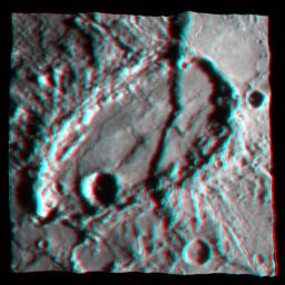
PIA11078: Mercury - in 3-D!
 Target Name:  Mercury
 Is a satellite of:  Sol (our sun)
 Mission:  MESSENGER
 Spacecraft:  MESSENGER
 Instrument:  MDIS - Narrow Angle
MDIS - Wide Angle
 Product Size:  600 x 600 pixels (w x h)
 Produced By:  Johns Hopkins University/APL
 Other  
Information: 
You will need 3D glasses
 Full-Res TIFF:  PIA11078.tif (1.081 MB)
 Full-Res JPEG:  PIA11078.jpg (60.73 kB)

Click on the image above to download a moderately sized image in JPEG format (possibly reduced in size from original)

Original Caption Released with Image:

This graphic shows a portion of the fault scarp Beagle Rupes (see PIA10939) cutting through the highly elliptical crater Sveinsdóttir in a three-dimensional (3D) representation. By combining information from multiple images of the same portion of Mercury's surface taken under different viewing angles, the topography of the surface was determined. A high-resolution image was then overlaid on the topography map, resulting in this 3D image. In total, over 80 MESSENGER images were used to create this 3D view of Mercury's surface. As the MESSENGER mission continues, many more images will be acquired, and these additional images will provide views of Mercury's surface from a variety of illumination conditions and viewing geometries. These myriad views, anchored by topographic profiles to be acquired by MESSENGER's laser altimeter, will enable large portions of the surface of Mercury to be studied in 3D.

Date Acquired: January 14, 2008
Image Mission Elapsed Time (MET) : NAC image from 108830230 resampled on a topographic map made from more than 80 NAC and WAC images.
Instrument: Narrow Angle Camera (NAC) and Wide Angle Camera (WAC) of the Mercury Dual Imaging System (MDIS)
Scale: Sveinsdóttir crater is about 120 kilometers by 220 kilometers (75 miles by 140 miles).

These images are from MESSENGER, a NASA Discovery mission to conduct the first orbital study of the innermost planet, Mercury. For information regarding the use of images, see the MESSENGER image use policy.

Image Credit:
NASA/Johns Hopkins University Applied Physics Laboratory/Carnegie Institution of Washington/Planetary Science Institute

Image Addition Date:
2008-09-09