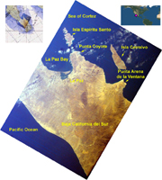
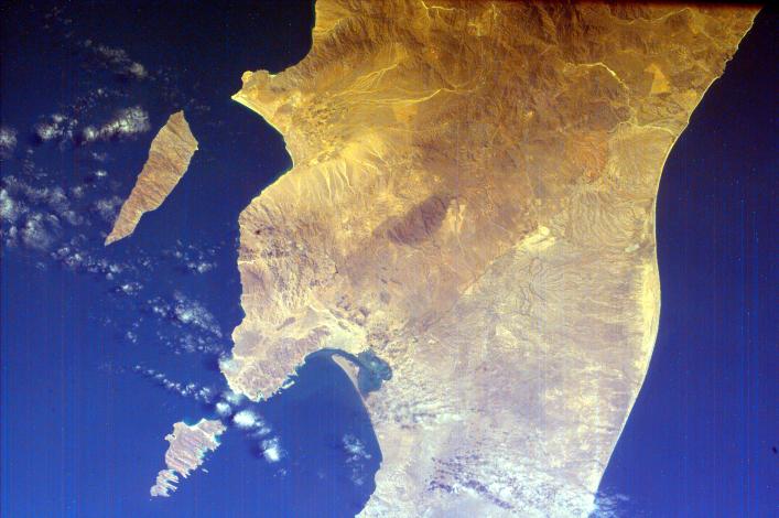
Click on image for larger annotated versionThis is an image of the southern portion of the Baja California Peninsula. The Pacific Ocean lies to the west and the Gulf of California to the east. Within the Gulf of California are Isla Cerralvo (the more southern of the two visible islands) and Isla Espiritu Santo. Ecologists work to keep these islands pristine so existing flora and fauna survive and so visitors can learn about the sea and enjoy the white sand beaches, the multi-colored cliffs and the sea life. Magdalena Bay is the smaller enclosed bay within the Bahia de La Paz. The town of La Paz lies on the peninsula surrounding Magdalena Bay. La Paz is the capital of the state of Baja California Sur. Surrounded by a barren desert; the city of La Paz is set amid ancient laurel trees, and coconut and date palms. La Paz draws sport fishermen, divers, and water enthusiasts to its sunny beaches, calm bays and ecologically pure offshore islands.
Magdalena Bay is one of three major lagoons traditionally used by California gray whales for breeding in Baja. The bay has a narrow opening to the Pacific Ocean, through which the tide flushes water in and out, bringing nutrients and oxygen to the diverse marine inhabitants. The water becomes a soup of minute organisms and fish, which in turn attract seabirds of many species during the winter months. Sea kayaking and bird in the mangrove canals of the calm and sunny lagoon is activities commonly enjoyed at Magdalena Bay.
This image was taken from the Space Shuttle on February 12, 2000.
NASA's ISS EarthKAM is made possible by the cooperative work of Sally Ride Science; undergraduate students and their advisors at the University of California, San Diego; NASA's Jet Propulsion Laboratory (JPL) in Pasadena, Calif.; NASA's Johnson Space Center (JSC) in Houston, Texas; and middle school teachers and their students worldwide.
Photojournal note:
EarthKAM was formerly known as KidSat. To see images of KidSat, see https://photojournal.jpl.nasa.gov/mission/KidSat .
