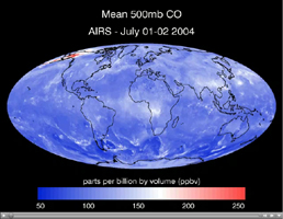
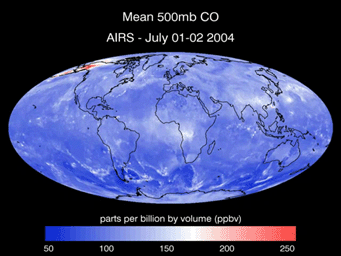
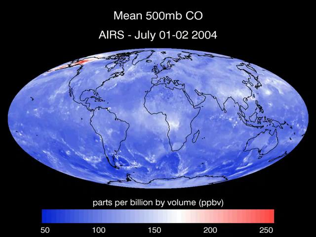
Click on image to view the movieThis series of maps created from data retrieved by the Atmospheric Infrared Sounder, AIRS, in July 2004 shows the transport of carbon monoxide (CO) gas, generated by fires in Alaska, as it moves through the atmosphere across Canada, the United States and the Atlantic Ocean. The data was retrieved at 500 millibar pressure, which is approximately 18,000 feet (3.5 miles) in altitude. Besides Alaska, the maps reveal high concentrations of CO originating in China and Russia which travel across the Pacific Ocean to the northwestern United States. Central Africa exhibits another large concentration of CO. These concentrations are also likely to indicate large scale forest burning. Carbon monoxide, CO, is a colorless and odorless gas formed when carbon in fuel is not burned completely. High levels of CO can cause health problems, and higher levels can be poisonous.
About AIRS
The Atmospheric Infrared Sounder, AIRS, in conjunction with the Advanced Microwave Sounding Unit, AMSU, senses emitted infrared and microwave radiation from Earth to provide a three-dimensional look at Earth's weather and climate. Working in tandem, the two instruments make simultaneous observations all the way down to Earth's surface, even in the presence of heavy clouds. With more than 2,000 channels sensing different regions of the atmosphere, the system creates a global, three-dimensional map of atmospheric temperature and humidity, cloud amounts and heights, greenhouse gas concentrations, and many other atmospheric phenomena. Launched into Earth orbit in 2002, the AIRS and AMSU instruments fly onboard NASA's Aqua spacecraft and are managed by NASA's Jet Propulsion Laboratory in Pasadena, Calif., under contract to NASA. JPL is a division of the California Institute of Technology in Pasadena.
More information about AIRS can be found at http://airs.jpl.nasa.gov.