PDS logoPlanetary Data System
PDS Information
Find a Node - Use these links to navigate to any of the 8 publicly accessible PDS Nodes.

This bar indicates that you are within the PDS enterprise which includes 6 science discipline nodes and 2 support nodes which are overseen by the Project Management Office at NASA's Goddard Space Flight Center (GSFC). Each node is led by an expert in the subject discipline, supported by an advisory group of other practitioners of that discipline, and subject to selection and approval under a regular NASA Research Announcement.
Click here to return to the Photojournal Home Page Click here to view a list of Photojournal Image Galleries Photojournal_inner_header
Latest Images  |  Spacecraft & Technology  |  Animations  |  Space Images App  |  Feedback  |  Photojournal Search  

PIA11013: Mapping a Volcano
 Target Name:  Mercury
 Is a satellite of:  Sol (our sun)
 Mission:  MESSENGER
 Spacecraft:  MESSENGER
 Instrument:  MDIS - Narrow Angle
 Product Size:  722 x 1280 pixels (w x h)
 Produced By:  Johns Hopkins University/APL
 Full-Res TIFF:  PIA11013.tif (925.3 kB)
 Full-Res JPEG:  PIA11013.jpg (107.8 kB)

Click on the image above to download a moderately sized image in JPEG format (possibly reduced in size from original)

Original Caption Released with Image:

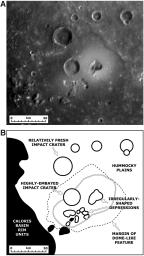
MESSENGER Science Team members are busy studying in detail the newly discovered volcanoes on Mercury (see PIA10942). This figure, recently published in Science magazine, shows a NAC mosaic of the largest volcano currently identified on Mercury and a geologic sketch map of the major features in the surrounding area. The “irregularly-shaped depressions” are believed to correspond to volcanic vents, and the “margin of the dome-like feature” marks the outer limits of lava flows from the vents that are thought to have covered up the underlying surface of “hummocky plains.” The unlabeled double line outlines bright material associated with the volcano, believed to be pyroclastic deposits ejected during volcanic eruptions at the vents. A “highly-embayed impact crater” also appears to have had lava flow up to its rim, while a slightly more distant impact crater is “relatively fresh” and unchanged by any lava. The volcano is located just inside the rim of the Caloris impact basin (see PIA10383), labeled as “Caloris basin rim units” on this map. Maps such as this are aiding scientists as they work to understand the history of volcanism on Mercury.

Date Acquired: January 14, 2008
Image Mission Elapsed Time (MET): Mosaic of 108826812 and 108826877
Instrument: A: Narrow Angle Camera (NAC) of the Mercury Dual Imaging System (MDIS)
Spacecraft Altitude: 10,500 kilometers (6,500 miles)

These images are from MESSENGER, a NASA Discovery mission to conduct the first orbital study of the innermost planet, Mercury. For information regarding the use of images, see the MESSENGER image use policy.

Image Credit:
NASA/Johns Hopkins University Applied Physics Laboratory/Arizona State University/Carnegie Institution of Washington. Figure 1 from Head et al., Science, 321, 69-72, 2008.

Image Addition Date:
2008-08-19