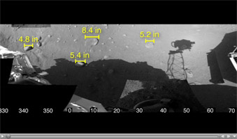
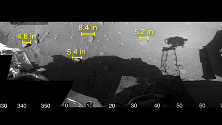
Click on image for animationThis animation shows a mosaic of images of the workspace reachable by the scoop on the robotic arm of NASA's Phoenix Mars Lander, along with some measurements of rock sizes.
Phoenix was able to determine the size of the rocks based on three-dimensional views from stereoscopic images taken by the lander's 7-foot mast camera, called the Surface Stereo Imager. The stereo pair of images enable depth perception, much the way a pair of human eyes enable people to gauge the distance to nearby objects.
The rock measurements were made by a visualization tool known as Viz, developed at NASA's Ames Research Laboratory. The shadow cast by the camera on the Martian surface appears somewhat disjointed because the camera took the images in the mosaic at different times of day.
Scientists do not yet know the origin or composition of the flat, light-colored rocks on the surface in front of the lander.
The Phoenix Mission is led by the University of Arizona, Tucson, on behalf of NASA. Project management of the mission is by NASA's Jet Propulsion Laboratory, Pasadena, Calif. Spacecraft development is by Lockheed Martin Space Systems, Denver.
Photojournal Note: As planned, the Phoenix lander, which landed May 25, 2008 23:53 UTC, ended communications in November 2008, about six months after landing, when its solar panels ceased operating in the dark Martian winter.