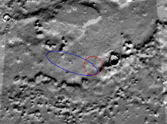
This image shows the latest estimate, marked by a green crosshair, of the location of NASA's Phoenix Mars Lander. Radio communications between Phoenix and spacecraft flying overhead have allowed engineers to narrow the lander's location to an area about 300 meters (984) long by 100 meters (328 feet) across, or about three football fields long and one football field wide.
During landing, Phoenix traveled across the field of view shown here from the upper left to the lower right. The area outlined in blue represents the area where Phoenix was predicted to land before arriving on Mars. During Phoenix's descent through the Martian atmosphere to the surface of the Red Planet, continuous measurements of the distance the spacecraft traveled enabled engineers to narrow its location further to the circular area outlined in red.
Using radio signals to home in on Phoenix's final location is sort of like trying to find a kitten by listening to the sound of its meows. As NASA's Odyssey spacecraft passes overhead, it receives radio transmissions from the lander. When Odyssey passes overhead again along a slightly different path, it receives new radio signals. With each successive pass, it is able to "fix" the location of Phoenix a little more precisely.
Meanwhile, NASA's Mars Reconnaissance Orbiter has taken actual images of the spacecraft on the surface, enabling scientists to match the lander's location to geologic features seen from orbit.
The large crater to the right is "Heimdall crater," the slopes of which are visible in images of the parachute that lowered Phoenix to the surface, taken by the High Resolution Imaging Science Experiment instrument on the Mars Reconnaissance Orbiter. The map shown here is made up of topography data taken by NASA's Mars Global Surveyor. It shows exaggerated differences in the height of the terrain.
The Phoenix Mission is led by the University of Arizona, Tucson, on behalf of NASA. Project management of the mission is by NASA's Jet Propulsion Laboratory, Pasadena, Calif. Spacecraft development is by Lockheed Martin Space Systems, Denver.
Photojournal Note: As planned, the Phoenix lander, which landed May 25, 2008 23:53 UTC, ended communications in November 2008, about six months after landing, when its solar panels ceased operating in the dark Martian winter.