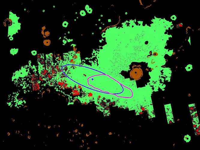
This map illustrates where NASA's Phoenix Mars Lander is targeted to land on May 25, 2008, based on expectations as of noon pacific time (3 p.m. eastern time), May 24, 2008. Phoenix is most likely to land at the cross-shaped target at the center of the blue ellipse and least likely to land at the ellipse's edges.
The area outlined in magenta reflects criteria being used to consider whether Phoenix engineers will perform another trajectory correction maneuver. If measurements taken later today determine that the spacecraft is still on target to land within the magenta area, they will not correct its course. If the spacecraft is outside this region, its course will be corrected.
In this map, green denotes safe-landing regions deemed to have few rocks through high-resolution imagery. Red represents unsafe, rocky territory.
The blue ellipse is approximately 70 kilometers (44 miles) long.
The Phoenix Mission is led by the University of Arizona, Tucson, on behalf of NASA. Project management of the mission is by NASA's Jet Propulsion Laboratory, Pasadena, Calif. Spacecraft development is by Lockheed Martin Space Systems, Denver.
Photojournal Note: As planned, the Phoenix lander, which landed May 25, 2008 23:53 UTC, ended communications in November 2008, about six months after landing, when its solar panels ceased operating in the dark Martian winter.