The Compact Reconnaissance Imaging Spectrometer for Mars (CRISM) took this image of sulfate- and pyroxene-containing deposits in the Candor Chasma region of Mars at 0747 UTC (2:47 a.m. EST) on December 2, 2006, near 6.7 degrees south latitude, 75.8 degrees west longitude. The image was taken in 544 colors covering 0.36-3.92 micrometers, and shows features as small as 40 meters (132 feet) across. The image is about 10 kilometers (6.2 miles) wide at its narrowest point.
Candor Chasma is a deep, elongated, steep-sided depression some 813 kilometers (505 miles) long. It is one of two large chasmata that make up the northern end of the Valles Marineris system.
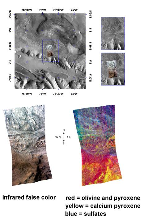
The top panel in the montage above illustrates the location of CRISM data on a mosaic taken by the Mars Odyssey spacecraft's Thermal Emission Imaging System (THEMIS). CRISM data cover an area centered on the southwestern part of Candor Chasma, where highland crust was depressed by faulting and buried by a kilometers-thick stack of layered deposits.
The bottom two images are views of CRISM data. The lower left image is an infrared false color image, while at lower right is a spectral image that illustrates the distribution of sulfates in the layered deposits, the olivine and pyroxene that make up the faulted highland crust, and high-calcium pyroxene in the highland crust.
The northern part of CRISM's data swath covers interior deposits formed after the canyon floor was faulted and depressed. This lighter region in the infrared image at lower left exhibits the spectral signatures of sulfates (blues) in the CRISM spectral image at lower right. The southern end of CRISM's data reveals volcanic minerals (pyroxene and olivine) that make up the older, underlying highland crust. The strongest signature comes from the common diopside-hedenbergite series of pyroxenes—a group of silicate materials rich in iron, magnesium, and calcium.
CRISM is one of six science instruments on NASA's Mars Reconnaissance Orbiter. Led by The Johns Hopkins University Applied Physics Laboratory, Laurel, Md., the CRISM team includes expertise from universities, government agencies and small businesses in the United States and abroad. NASA's Jet Propulsion Laboratory, a division of the California Institute of Technology in Pasadena, manages the Mars Reconnaissance Orbiter and the Mars Science Laboratory for NASA's Science Mission Directorate, Washington. Lockheed Martin Space Systems, Denver, built the orbiter.