This image of layered deposits in Aureum Chaos was taken by the Compact Reconnaissance Imaging Spectrometer for Mars (CRISM) on June 6, 2007 at 0347 UTC (11:47 p.m. EDT on June 5, 2007), near 3.5 degrees south latitude, 333.25 degrees east longitude. The CRISM image was taken in 544 colors covering 0.36-3.92 micrometers, and shows features as small as 40 meters (132 feet) across. The region covered is just over 10 kilometers (6 miles) wide at its narrowest point.
Aureum Chaos lies in the eastern part of the Valles Marineris canyon system, southwest of a 280 kilometer (174 mile) diameter, highly modified impact crater called Aram Chaos. Both regions hold examples of chaotic terrain that is characterized by randomly oriented, large-scale mesas and knobs. In this region of Mars, these features range in size from a few kilometers to tens of kilometers wide and tend to be heavily eroded. As its name implies, chaotic terrain is extremely irregular. It is most likely the result of collapsed surface material that settled when subsurface ice, water, or magma was released.
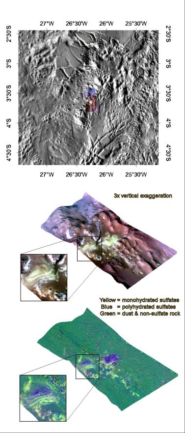
The top panel in the montage above shows the location of the CRISM image on a mosaic taken by the Mars Odyssey spacecraft's Thermal Emission Imaging System (THEMIS). The CRISM data cover an area riddled with knobs. The lower two images were constructed by draping CRISM images over topography and exaggerating the vertical scale to better illustrate the region's topography. The upper right is an infrared, false color image that reveals layered deposits of a light-colored material along the flanks of several knobs. The lower-left image reveals the mineralogical composition of these layers, with yellow representing monohydrated sulfates (sulfates with one water molecule incorporated into each molecule of the mineral) and blue polyhydrated sulfates (sulfates with multiple waters per mineral molecule). There are two possible explanations for the compositional banding. The first is deposition of mono- and polyhydrated sulfates in alternating layers. The second is deposition of just one sulfate type, and subsequently its alteration by weathering at the exposed, eroded surface. Further observations will better determine the origin of these complex banded sulfate deposits.
CRISM is one of six science instruments on NASA's Mars Reconnaissance Orbiter. Led by The Johns Hopkins University Applied Physics Laboratory, Laurel, Md., the CRISM team includes expertise from universities, government agencies and small businesses in the United States and abroad. NASA's Jet Propulsion Laboratory, a division of the California Institute of Technology in Pasadena, manages the Mars Reconnaissance Orbiter and the Mars Science Laboratory for NASA's Science Mission Directorate, Washington. Lockheed Martin Space Systems, Denver, built the orbiter.