PDS logoPlanetary Data System
PDS Information
Find a Node - Use these links to navigate to any of the 8 publicly accessible PDS Nodes.

This bar indicates that you are within the PDS enterprise which includes 6 science discipline nodes and 2 support nodes which are overseen by the Project Management Office at NASA's Goddard Space Flight Center (GSFC). Each node is led by an expert in the subject discipline, supported by an advisory group of other practitioners of that discipline, and subject to selection and approval under a regular NASA Research Announcement.
Click here to return to the Photojournal Home Page Click here to view a list of Photojournal Image Galleries Photojournal_inner_header
Latest Images  |  Spacecraft & Technology  |  Animations  |  Space Images App  |  Feedback  |  Photojournal Search  

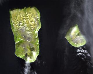
PIA10631: Diomede Islands, Bering Straight
 Target Name:  Earth
 Is a satellite of:  Sol (our sun)
 Mission:  Terra
 Spacecraft:  Terra
 Instrument:  ASTER
 Product Size:  900 x 720 pixels (w x h)
 Produced By:  JPL
 Full-Res TIFF:  PIA10631.tif (1.946 MB)
 Full-Res JPEG:  PIA10631.jpg (67.39 kB)

Click on the image above to download a moderately sized image in JPEG format (possibly reduced in size from original)

Original Caption Released with Image:

The Diomede Islands consisting of the western island Big Diomede (also known as Imaqliq, Nunarbuk or Ratmanov Island), and the eastern island Little Diomede (also known as Krusenstern Island or Inaliq), are two rocky islands located in the middle of the Bering Strait between Russia and Alaska. The islands are separated by an international border and the International Date Line which is approximately 1.5 km from each island; you can look from Alaska into tomorrow in Russia. At the closest land approach between the United States, which controls Little Diomede, and Russia, which controls Big Diomede, they are 3 km apart. Little Diomede Island constitutes the Alaskan City of Diomede, while Big Diomede Island is Russia's easternmost point. The first European to reach the islands was the Russian explorer Semyon Dezhnev in 1648. The text of the 1867 treaty finalizing the sale of Alaska uses the islands to designate the border between the two nations.

The image was acquired July 8, 2000, covers an area of 13.5 x 10.8 km, and is located at 65.8 degrees north latitude, 169 degrees west longitude.

The U.S. science team is located at NASA's Jet Propulsion Laboratory, Pasadena, Calif. The Terra mission is part of NASA's Science Mission Directorate.

Image Credit:
NASA/GSFC/METI/ERSDAC/JAROS, and U.S./Japan ASTER Science Team

Image Addition Date:
2008-04-30