 |  |
| Top Image | Bottom Image |
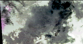
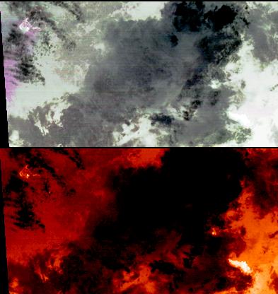
On the night of March 25, 2008, the Advanced Spaceborne Thermal Emission and Reflection Radiometer instrument on NASA's Terra satellite captured these thermal infrared images of Kilauea volcano on Hawaii's Big Island. Kilauea was active at two locations. At the summit, Halema'uma'u vent inside the Kilauea crater, continued to erupt an ash plume, seen as the magenta cloud on the left side of the top image. Some of the time this eruption has been dominated by sulfur dioxide gas and steam. The National Park Service has closed off the area due to extreme health hazards. On the second image, temperatures are color-coded in shades of red, from dark red (colder) to white (hotter). The Halema'uma'u vent appears as a white (hot) area. At the coast, the Thanksgiving Eve Breakout flow continues to build new land area as it enters the ocean (bright white area in lower right corner of bottom image).
With its 14 spectral bands from the visible to the thermal infrared wavelength region, and its high spatial resolution of 15 to 90 meters (about 50 to 300 feet), ASTER images Earth to map and monitor the changing surface of our planet.
Click on the link for a live USGS webcam of the summit, http://hvo.wr.usgs.gov/cam3/.
ASTER is one of five Earth-observing instruments launched December 18, 1999, on NASA's Terra satellite. The instrument was built by Japan's Ministry of Economy, Trade and Industry. A joint U.S./Japan science team is responsible for validation and calibration of the instrument and the data products.
The broad spectral coverage and high spectral resolution of ASTER provides scientists in numerous disciplines with critical information for surface mapping, and monitoring of dynamic conditions and temporal change. Example applications are: monitoring glacial advances and retreats; monitoring potentially active volcanoes; identifying crop stress; determining cloud morphology and physical properties; wetlands evaluation; thermal pollution monitoring; coral reef degradation; surface temperature mapping of soils and geology; and measuring surface heat balance.
The U.S. science team is located at NASA's Jet Propulsion Laboratory, Pasadena, Calif. The Terra mission is part of NASA's Science Mission Directorate.
Size: 35.4 by 18.7 kilometers (21.9 by 11.5 miles)
Location: 19.3 degrees North latitude, 155 degrees West longitude
Orientation: North at top
Image Data: ASTER bands 13, 12, and 10
Original Data Resolution: 90 meters (295 feet)
Dates Acquired: March 25, 2008


