PDS logoPlanetary Data System
PDS Information
Find a Node - Use these links to navigate to any of the 8 publicly accessible PDS Nodes.

This bar indicates that you are within the PDS enterprise which includes 6 science discipline nodes and 2 support nodes which are overseen by the Project Management Office at NASA's Goddard Space Flight Center (GSFC). Each node is led by an expert in the subject discipline, supported by an advisory group of other practitioners of that discipline, and subject to selection and approval under a regular NASA Research Announcement.
Click here to return to the Photojournal Home Page Click here to view a list of Photojournal Image Galleries Photojournal_inner_header
Latest Images  |  Spacecraft & Technology  |  Animations  |  Space Images App  |  Feedback  |  Photojournal Search  

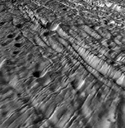
PIA10351: Ancient Cratered Terrains on Enceladus - A Complex Deformation History
 Target Name:  Enceladus
 Is a satellite of:  Saturn
 Mission:  Cassini-Huygens
 Spacecraft:  Cassini Orbiter
 Instrument:  ISS - Narrow Angle
Imaging Science Subsystem - Wide Angle 
 Product Size:  864 x 884 pixels (w x h)
 Produced By:  Lunar and Planetary Institute
 Primary Data Set:  Cassini
 Full-Res TIFF:  PIA10351.tif (764.8 kB)
 Full-Res JPEG:  PIA10351.jpg (141 kB)

Click on the image above to download a moderately sized image in JPEG format (possibly reduced in size from original)

Original Caption Released with Image:

The topography of planetary surfaces tells us much about the geologic history and forces involved, and volcanically active Enceladus is no exception. New topographic maps give us a fresh unprecedented look at this tortured moon. This perspective view shows the oldest most heavily cratered terrains on the surface. Long ridges and grooves and numerous younger narrow parallel fractures cut across many of these craters, showing that even this ancient terrain has not escaped the extensive tectonic deformation that has wracked this small icy moon. The larger craters in the foreground are typically 2 kilometers across and a few hundred meters deep. This perspective view was constructed from digital elevation models produced by Dr. Paul Schenk (http://www.lpi.usra.edu/lpi/schenk/) at the Lunar and Planetary Institute in Houston, TX, based on stereo and shape-from-shading analysis of Cassini images acquired in March 2005. Vertical relief has been exaggerated by a factor of 10 to aid interpretation.

The raw data from which this product was developed were retrieved from the Planetary Data System's Cassini archives. The Cassini-Huygens mission is a cooperative project of NASA, the European Space Agency and the Italian Space Agency. The Jet Propulsion Laboratory, a division of the California Institute of Technology in Pasadena, manages the mission for NASA's Science Mission Directorate, Washington, D.C. The Cassini orbiter and its two onboard cameras were designed, developed and assembled at JPL. The imaging operations center is based at the Space Science Institute in Boulder, Colo. (http://ciclops.org)

Image Credit:
NASA/JPL/Space Science Institute/Universities Space Research Association/Lunar & Planetary Institute

Image Addition Date:
2008-03-25