PDS logoPlanetary Data System
PDS Information
Find a Node - Use these links to navigate to any of the 8 publicly accessible PDS Nodes.

This bar indicates that you are within the PDS enterprise which includes 6 science discipline nodes and 2 support nodes which are overseen by the Project Management Office at NASA's Goddard Space Flight Center (GSFC). Each node is led by an expert in the subject discipline, supported by an advisory group of other practitioners of that discipline, and subject to selection and approval under a regular NASA Research Announcement.
Click here to return to the Photojournal Home Page Click here to view a list of Photojournal Image Galleries Photojournal_inner_header
Latest Images  |  Spacecraft & Technology  |  Animations  |  Space Images App  |  Feedback  |  Photojournal Search  

PIA10247: Chloride Salt Deposit in Southern Highlands of Mars
 Target Name:  Mars
 Is a satellite of:  Sol (our sun)
 Mission:  2001 Mars Odyssey
 Spacecraft:  2001 Mars Odyssey
 Instrument:  THEMIS
 Product Size:  4733 x 3422 pixels (w x h)
 Produced By:  Arizona State University
 Full-Res TIFF:  PIA10247.tif (48.59 MB)
 Full-Res JPEG:  PIA10247.jpg (1 MB)

Click on the image above to download a moderately sized image in JPEG format (possibly reduced in size from original)

Original Caption Released with Image:

Click here for annotated version of PIA10247 Chloride Salt Deposit in Southern Highlands of Mars
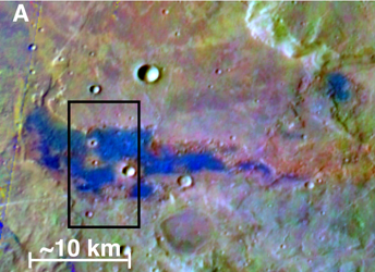
Annotated figure

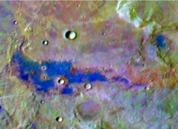
Bright blue marks a deposit of chloride (salt) minerals in the southern highlands of Mars in this false-color image, which highlights mineral composition differences. The Thermal Emission Imaging System (THEMIS) camera on NASA's Mars Odyssey orbiter made this observation. Researchers using THEMIS reported in March 2008 that they have found about 200 such deposits of chloride salts. Observations by THEMIS and other instruments orbiting Mars indicate that these deposits typically lie within topographic depressions. The salt deposits suggest that Mars was much wetter long ago. They point to places where water was once abundant, then evaporated, leaving the minerals behind.

This site lies at about 221 degrees east longitude and 38.8 degrees south latitude, within the rugged Terra Sirenum region of Mars. The view is a portion of an image taken by THEMIS on Dec. 11, 2003. The full image is at http://themis-data.asu.edu/img/I08831002?tab=1.

The scale bar is about 10 kilometers (6.2 miles). The black rectangle indicates the outline of a higher resolution view, available as PIA10248.

NASA's Jet Propulsion Laboratory, a division of the California Institute of Technology, Pasadena, manages the Mars Odyssey mission for the NASA Science Mission Directorate, Washington. The Thermal Emission Imaging System (THEMIS) was developed by Arizona State University, Tempe, in collaboration with Raytheon Santa Barbara Remote Sensing. Lockheed Martin Space Systems, Denver, is the prime contractor for the Odyssey project, and developed and built the orbiter.

Image Credit:
NASA/JPL-Caltech/Arizona State University/University of Hawaii

Image Addition Date:
2008-03-20