 | 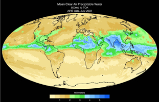 |
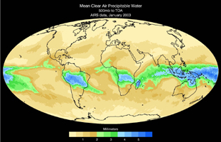
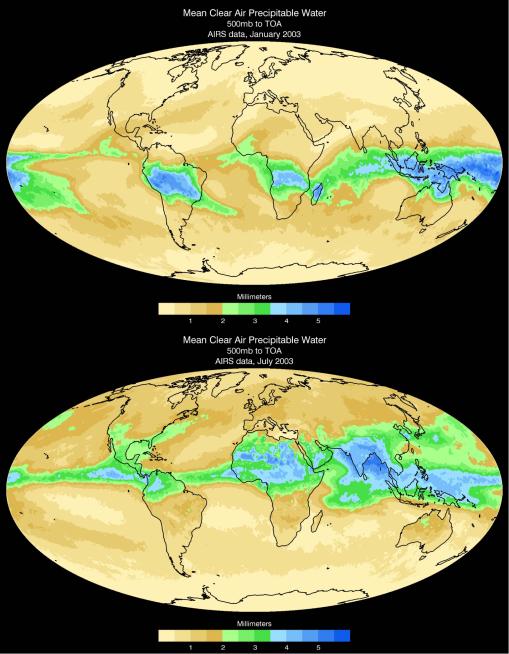
| January Map | July Map |
Water vapor is the dominant greenhouse gas in our atmosphere. The greenhouse effect of water vapor is enhanced at high altitudes, where the air is significantly colder than the ground, and increases rapidly as the temperature contrast grows. As a result, the small fraction of 5-10% of water molecules above 500 hPa altitude produces half the total greenhouse effect of the atmosphere. The height at which atmospheric pressure is 500 hPa roughly divides in half the atmosphere vertically, half the mass of air being above and half below that height.
AIRS, The Atmospheric Infrared Sounder, can look at distinct levels of the atmosphere. This pair of maps show the average distribution of water vapor from 500 millibars, approximately 14,000 feet in altitude, to the top of the atmosphere. The shift of water vapor towards the northern hemisphere from January to July is apparent. Note that this layer is also much drier than the atmosphere as a whole. This map is also significant because it's the first of its kind. AIRS is the first instrument with the ability to isolate water vapor content to layers of the atmosphere.
About AIRS
The Atmospheric Infrared Sounder, AIRS, in conjunction with the Advanced Microwave Sounding Unit, AMSU, senses emitted infrared and microwave radiation from Earth to provide a three-dimensional look at Earth's weather and climate. Working in tandem, the two instruments make simultaneous observations all the way down to Earth's surface, even in the presence of heavy clouds. With more than 2,000 channels sensing different regions of the atmosphere, the system creates a global, three-dimensional map of atmospheric temperature and humidity, cloud amounts and heights, greenhouse gas concentrations, and many other atmospheric phenomena. Launched into Earth orbit in 2002, the AIRS and AMSU instruments fly onboard NASA's Aqua spacecraft and are managed by NASA's Jet Propulsion Laboratory in Pasadena, Calif., under contract to NASA. JPL is a division of the California Institute of Technology in Pasadena.
More information about AIRS can be found at http://airs.jpl.nasa.gov.
 Planetary Data System


