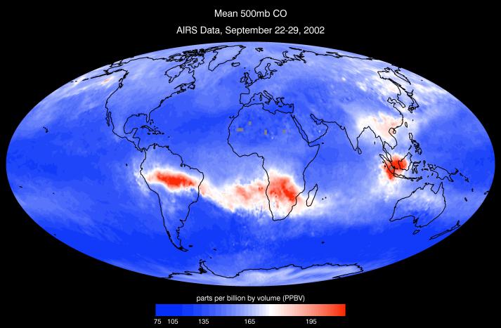
Given carbon monoxide's (CO) direct production from combustion and role as an ozone and smog precursor, detailed global observations of CO are crucial to assessing atmospheric health. Using the 1600 km cross-track swath and cloud-clearing retrieval capabilities of AIRS, daily global CO maps can be produced which cover approximately 80% of the planet. Analysis of these data from the first month of AIRS operation (September 2002) reveals daily evolution of large-scale, long-range transport of biomass burning and industrial pollution with unprecedented horizontal resolution and coverage. The depicted day, 29 September 2002, shows large biomass burning (slash-and-burn agriculture) source regions over central South America, Africa, and Indonesia. Time-sequence imaging of global images over a period of a week shows significant transport to the South Atlantic and Indian Oceans. At this time of year, North America and European industrial sources are at a minimum and a mix of industrial and biomass burning sources contribute in India, China, and Russia. Preliminary validation indicates AIRS CO retrievals are approaching the 15% accuracy target set by pre-launch simulations. With these global CO features heretofore glimpsed only in limited scope, AIRS observations will enable refinement of models simulating global climate change and provide critical monitoring of variations in greenhouse gas emissions.
About AIRS
The Atmospheric Infrared Sounder, AIRS, in conjunction with the Advanced Microwave Sounding Unit, AMSU, senses emitted infrared and microwave radiation from Earth to provide a three-dimensional look at Earth's weather and climate. Working in tandem, the two instruments make simultaneous observations all the way down to Earth's surface, even in the presence of heavy clouds. With more than 2,000 channels sensing different regions of the atmosphere, the system creates a global, three-dimensional map of atmospheric temperature and humidity, cloud amounts and heights, greenhouse gas concentrations, and many other atmospheric phenomena. Launched into Earth orbit in 2002, the AIRS and AMSU instruments fly onboard NASA's Aqua spacecraft and are managed by NASA's Jet Propulsion Laboratory in Pasadena, Calif., under contract to NASA. JPL is a division of the California Institute of Technology in Pasadena.
More information about AIRS can be found at http://airs.jpl.nasa.gov.
 Planetary Data System


