Approaching its 47th month of a Mars surface mission originally planned to last three months, NASA's Spirit rover was also approaching the northern edge of a low plateau called "Home Plate." The rover's operators selected an area with north-facing slope there as a destination where Spirit would have its best chance of surviving low-solar-energy conditions of oncoming Martian winter.
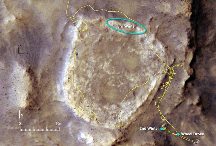
The yellow line on this map of the Home Plate area indicates Spirit's route from early February 2006, entering the mapped area from the north (top), to late November 2007, on the western edge of the bright-toned Home Plate plateau. The map covers an area about 160 meters (525 feet) across from west to east. Labels indicate the area intended for Spirit to spend many months spanning the rover's third Martian winter, the site where it spent about seven months (April to November 2006) spanning its second winter, and the site where it lost use of the drive motor for one of its six wheels.
A north-facing slope helps Spirit maximizes electric output from its solar panels during winter months because Spirit is in the southern hemisphere of Mars, so the sun appears only in the northern sky during winter. For the third winter, which will reach its minimum solar-energy days in early June 2008, Spirit faces the challenge of having more dust on its solar panels than it had during its second winter.
The base image for this map is a portion of a color image taken on Jan. 9, 2007, by the High Resolution Imaging Science Experiment camera on NASA's Mars Reconnaissance Orbiter.