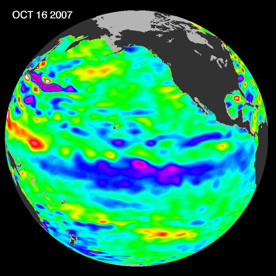
The tropical Pacific Ocean remains in the grips of a cool La Nińa, as shown by new data of sea-level heights from mid-October of 2007, collected by the U.S-French Jason altimetric satellite. This La Nińa, which has slowly strengthened for the past nine months, is indicated by the blue area in the center of the image along the equator. Blue indicates lower than normal sea level (cold water).
The new image is available at http://www.nasa.gov/vision/earth/lookingatearth/20071106.html.
"After eight very dry years on the Colorado River watershed and a record-breaking dry winter in Southern California in 2006-2007, the situation in the American Southwest is dangerously dry," said oceanographer Bill Patzert of NASA's Jet Propulsion Laboratory, Pasadena, Calif. "This La Nińa could deepen the drought in the already parched Southwest and Southeast United States."
Patzert and other scientists say La Nińa contributed to the conditions that fueled Southern California's recent deadly wildfires.
A La Nińa situation often follows an El Nińo episode and is essentially the opposite of an El Nińo condition. During a La Nińa, trade winds are stronger than normal, and the cold water that normally exists along the coast of South America extends to the central equatorial Pacific. A La Nińa changes global weather patterns and is associated with less moisture in the air, resulting in less rain along the coasts of North and South America, the equator and in the far Western Pacific. Jason will continue to track this change in Pacific climate.
This image of the Pacific Ocean was produced using sea-surface height measurements taken by Jason. The image is based on the average of 10 days of data centered on October 16, 2007, compared to the long-term average of observations from 1993 through 2005. In the image, places where the Pacific sea surface height is higher (warmer) than normal are yellow and red, and places where the sea surface is lower (cooler) than normal are blue and purple. Green shows where conditions are near normal. Sea-surface height is an indicator of the heat content of the upper ocean.
The comings and goings of El Nińo and La Nińa are part of a longer evolving state of global climate, of which sea-surface height is a useful indicator. The Jason follow-on mission, Ocean Surface Topography Mission/Jason-2, is scheduled for launch next June and will extend the data record to a span of two decades.
NASA's Jet Propulsion Laboratory manages the U.S. portion of the U.S./French Jason mission for NASA's Science Mission Directorate, Washington, D.C. JPL is a division of the California Institute of Technology, Pasadena, Calif.
For more information on NASA's ocean surface topography missions, see http://sealevel.jpl.nasa.gov/ or to view the latest Jason data see http://sealevel.jpl.nasa.gov/science/jason1-quick-look/.
