This image of the northern wall of Coprates Chasma, in Valles Marineris, was taken by the Compact Reconnaissance Imaging Spectrometer for Mars (CRISM) at 1227 UTC (8:27 a.m. EDT) on June 16, 2007, near 13.99 degrees south latitude, 303.09 degrees east longitude. CRISM's image was taken in 544 colors covering 0.36-3.92 micrometers, and shows features as small as 20 meters (66 feet) across. The region covered is just over 10 kilometers (6.2 miles) wide at its narrowest point.
Valles Marineris is a large canyon system straddling Mars' equator, with a total size approximating the Mediterranean Sea emptied of water. It is subdivided into several interconnected "chasmata" each hundreds of kilometers wide and, in some cases, thousands of kilometers long. The walls of several of the chasmata, including Coprates Chasma, expose a section of Mars' upper crust about 5 kilometers (3 miles) in depth. Exposures like these show the layers of rock that record the formation of Mars' crust over geologic time, much as the walls of the Grand Canyon on Earth show part of our planet's history.
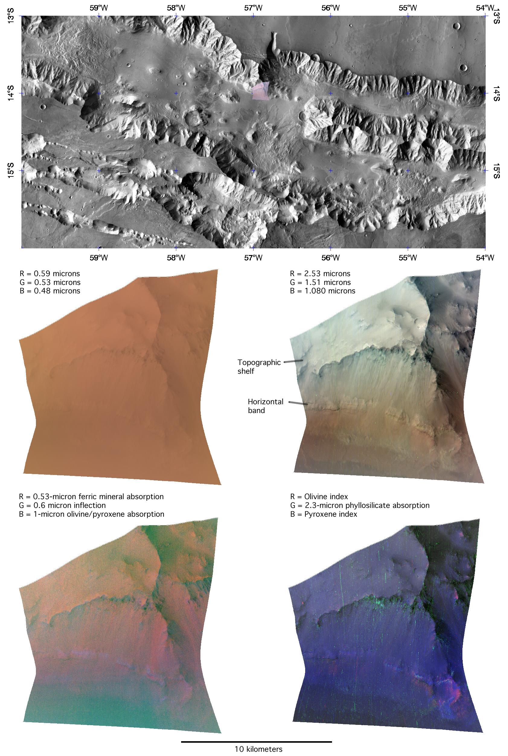
The upper panel of this montage shows the location of the CRISM image on a mosaic from the Mars Odyssey spacecraft's Thermal Emission Imaging System (THEMIS), taken in longer infrared wavelengths than measured by CRISM. The CRISM image samples the base of Coprates Chasma's wall, including a conspicuous horizontal band that continues along the wall for tens of kilometers to the east and west, and a topographic shelf just above that.
The middle two panels show the CRISM image in visible and infrared light. In the middle left panel, the red, green, and blue image planes show brightness at 0.59, 0.53, and 0.48 microns, similar to what the human eye would see. Color variations are subdued by the presence of dust on all exposed surfaces. In the middle right panel, the red, green, and blue image planes show brightness at 2.53, 1.51, and 1.08 microns. These three infrared wavelengths are the "usual" set that the CRISM team uses to provide an overview of infrared data, because dust has a less obscuring effect, and because they are sensitive to a wide variety of minerals. Layering is clearly evident in the wall rocks. The conspicuous band running along the base of the chasma wall appears slightly yellowish, and the scarp at the edge of the topographic bench appears slightly green.
The bottom two panels use combinations of wavelengths to show the strengths of absorptions that provide "fingerprints" of different minerals. In the lower left panel, red shows strength of a 0.53-micron absorption due to oxidized iron in dust, green shows strength of an inflection in the spectrum at 0.6 microns that may be related to rock coatings, and blue shows strength of a 1-micron absorption due to the igneous minerals olivine and pyroxene. The conspicuous horizontal band appears slightly blue, indicating a stronger signature of olivine and/or pyroxene. In the lower right panel, red is a measure of an absorption particular to olivine, green is a measure of a 2.3-micron absorption due to phyllosilicates (clay-like minerals formed when rock was subjected to liquid water), and blue is a measure of absorptions particular to pyroxene. The conspicuous horizontal band is now resolved into an upper portion richer in pyroxene, underlain by material richer in olivine than the rest of the wall rock. Also, erosion-resistant material forming the topographic bench is underlain by phyllosilicate-containing material exposed on the scarp.
Taken together, these data reveal a layer cake-like composition of the crustal material exposed in Coprates Chasma's wall. Most of the rock is rich in pyroxene, which is expected because much of Mars' crust consists of volcanic basaltic rock. However discrete layers are richer in olivine, and in some layers the presence of phyllosilicates indicates interaction of rock with liquid water. Because the phyllosilicate-containing layer is low on the walls and deeply buried, it likely represents an early period of Mars' history that was exposed when the canyon system formed.
The Compact Reconnaissance Imaging Spectrometer for Mars (CRISM) is one of six science instruments on NASA's Mars Reconnaissance Orbiter. Led by The Johns Hopkins University Applied Physics Laboratory, the CRISM team includes expertise from universities, government agencies and small businesses in the United States and abroad.
