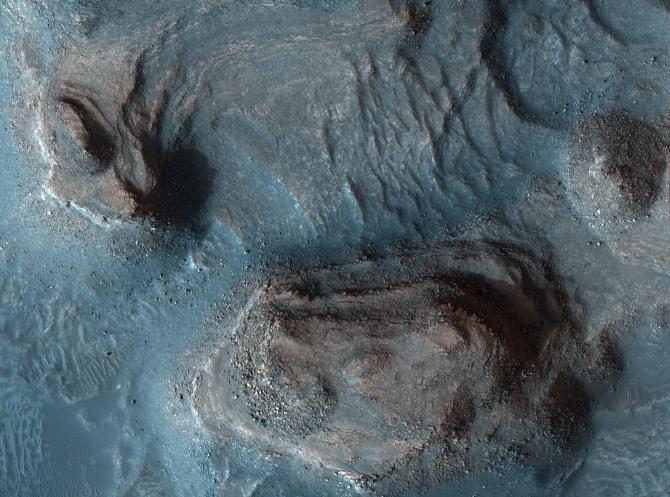
Mesas in the Nilosyrtis Mensae region of Mars appear in enhanced color in this image from the High Resolution Imaging Science Experiment (HiRISE) camera on NASA's Mars Reconnaissance Orbiter. The image was taken on April 5, 2007, as part of a campaign to examine more than two dozen candidate landing sites for the NASA Mars Science Laboratory rover, which is scheduled for launch in 2009.
This image shows a region of science interest to which the Mars Science Laboratory rover might drive. It would need to first land in a nearby area that is flatter and less rocky. Clay minerals have been detected in this region by imaging spectrometers on the European Space Agency's Mars Express orbiter and on the Mars Reconnaissance Orbiter. These minerals are of great interest in the search for evidence of life on ancient Mars. Someday the capability may exist for precision landing and hazard avoidance, so a rover could be set down right next to such rugged outcrops of interest for study and perhaps for collection of rock samples for return to Earth.
The area covered by this image is about one kilometer (six-tenths of a mile) across, at 29.3 degrees north latitude, 73.3 degrees east longitude. North is up. The view is a composite of exposures that HiRISE took in the infrared, red and blue portions of the spectrum. Color is enhanced, a technique useful for analyzing landscapes.
This is a portion of the full-frame color image catalogued as PSP_003231_2095 in the HiRISE collection. It was taken at a local Mars time of 3:28 p.m. The scene is illuminated from the west with a solar incidence angle of 66 degrees, thus the sun was about 24 degrees above the horizon. The season on Mars was northern autumn.