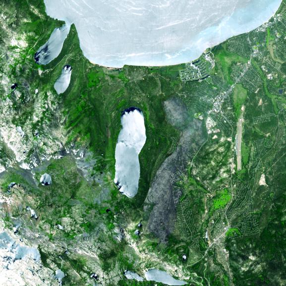
A destructive forest fire that broke out June 24, 2007 near South Lake Tahoe, Calif., continued to burn June 27 when this image was acquired by the Advanced Spaceborne Thermal Emission and Reflection Radiometer instrument on NASA's Terra satellite. As of June 28, the fire had destroyed about 230 residences and other buildings. In all, about 2,000 people were evacuated, according to South Lake Tahoe Police. The blaze has charred more than 3,100 acres -- about 4.8 square miles -- and was 60 percent contained on June 28. In this ASTER image, the burned area is in gray, a combination of burned forest and some smoke, between Fallen Leaf Lake and the Tahoe Airport.
With its 14 spectral bands from the visible to the thermal infrared wavelength region, and its high spatial resolution of 15 to 90 meters (about 50 to 300 feet), ASTER images Earth to map and monitor the changing surface of our planet.
ASTER is one of five Earth-observing instruments launched December 18, 1999, on NASA's Terra spacecraft. The instrument was built by Japan's Ministry of Economy, Trade and Industry. A joint U.S./Japan science team is responsible for validation and calibration of the instrument and the data products.
The broad spectral coverage and high spectral resolution of ASTER provides scientists in numerous disciplines with critical information for surface mapping, and monitoring of dynamic conditions and temporal change. Example applications are: monitoring glacial advances and retreats; monitoring potentially active volcanoes; identifying crop stress; determining cloud morphology and physical properties; wetlands evaluation; thermal pollution monitoring; coral reef degradation; surface temperature mapping of soils and geology; and measuring surface heat balance.
The U.S. science team is located at NASA's Jet Propulsion Laboratory, Pasadena, Calif. The Terra mission is part of NASA's Science Mission Directorate.
Size: 15 by 15 kilometers (9.3 by 9.3 miles)
Location: 38.9 degrees North latitude, 120 degrees West longitude
Orientation: North at top
Image Data: ASTER Bands 3, 2, and 1
Original Data Resolution: ASTER 15 meters (49.2 feet)
Date Acquired: June 27, 2007.