
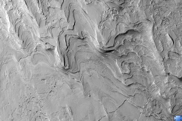
Click on image for larger versionThis HiRISE image (PSP_001897_1745) covers a portion of the layered deposits in Gale crater, but is located to the southeast of the main stack of the deposits and is perhaps revealing a lower part of the section.
The deposits are remarkably uniform at submeter scales and are not comprised of loose sediment, as evidenced by numerous fractures and scarps that run through and along some layers.
Though there are a few impact craters preserved, wind erosion has stripped and etched the surface of the layers, producing few large blocks and little in the way of talus or other debris.
The deposit's uniform character -- and the manner of erosion -- suggests it is comprised of fine-grained sediments, perhaps an accumulation of dust or volcanic ash blown in by the wind.
Observation Toolbox
Acquisition date: 12 December 2006
Local Mars time: 3:38 PM
Degrees latitude (centered): -5.3°
Degrees longitude (East): 138.3°
Range to target site: 267.3 km (167.1 miles)
Original image scale range: 26.7 cm/pixel (with 1 x 1 binning) so objects ~80 cm across are resolved
Map-projected scale: 25 cm/pixel and north is up
Map-projection: EQUIRECTANGULAR
Emission angle: 2.5°
Phase angle: 54.4°
Solar incidence angle: 57°, with the Sun about 33° above the horizon
Solar longitude: 154.3°, Northern Summer
NASA's Jet Propulsion Laboratory, a division of the California Institute of Technology in Pasadena, manages the Mars Reconnaissance Orbiter for NASA's Science Mission Directorate, Washington. Lockheed Martin Space Systems, Denver, is the prime contractor for the project and built the spacecraft. The High Resolution Imaging Science Experiment is operated by the University of Arizona, Tucson, and the instrument was built by Ball Aerospace and Technology Corp., Boulder, Colo.
