
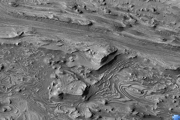
Click on image for larger versionThis HiRISE image (PSP_001984_1735) shows spectacular layers exposed on the bottom of Candor Chasma, which is a large canyon in the Valles Marineris system.
The floor here is approximately 4 km below the canyon rim. The layers are made of sand- and dust-sized particles that were transported here by either wind or water. This canyon may have been filled to its rim by these sedimentary layers, subsequently eroded away, most likely by the wind. The elongate hills may represent areas of rock that are stronger due to differences in the size of the sedimentary particles, chemical alteration, or both.
One of the most eye-catching aspects of this scene are the intricate swirls that these layers form. Sedimentary rock generally accumulates in horizontal layers. These layers, however, have been folded into the patterns that we see today. Folding of the layers that are exposed here may have occurred due to the weight of overlying sediments.
Understanding the geologic history of this region may provide clues into the history of water on Mars, because these layers may have accumulated in shallow lakes and may have undergone chemical reactions with this water. The presence of certain kinds of chemical reactions between water and rock can release energy that could have sustained habitable oases in these areas.
Observation Toolbox
Acquisition date: 12 December 2006
Local Mars time: 3:39 PM
Degrees latitude (centered): -6.5°
Degrees longitude (East): 283.1°
Range to target site: 261.6 km (163.5 miles)
Original image scale range: 26.2 cm/pixel (with 1 x 1 binning) so objects ~79 cm across are resolved
Map-projected scale: 25 cm/pixel and north is up
Map-projection: EQUIRECTANGULAR
Emission angle: 0.9°
Phase angle: 56.1°
Solar incidence angle: 57°, with the Sun about 33° above the horizon
Solar longitude: 157.8°, Northern Summer
NASA's Jet Propulsion Laboratory, a division of the California Institute of Technology in Pasadena, manages the Mars Reconnaissance Orbiter for NASA's Science Mission Directorate, Washington. Lockheed Martin Space Systems, Denver, is the prime contractor for the project and built the spacecraft. The High Resolution Imaging Science Experiment is operated by the University of Arizona, Tucson, and the instrument was built by Ball Aerospace and Technology Corp., Boulder, Colo.
