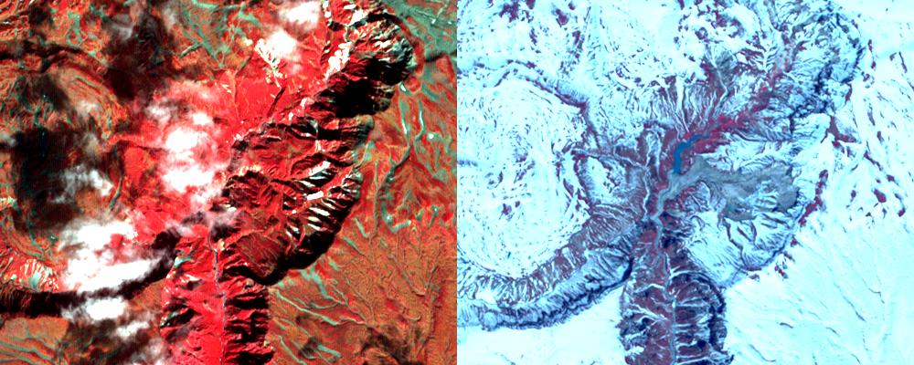
On June 2, a devastating mudslide in the world-renowned Geyser Valley on the Kamchatka Peninsula virtually obliterated the natural wonder, forcing the emergency evacuation of visitors and national park personnel. The site, which is the Kamchatka Peninsula's main tourist attraction, consists of some 200 thermal pools created by the area's intense volcanic activity, including about 90 geysers covering an area of four square kilometers (2.5 square miles). It is one of only five sites in the world where the impressive eruptions of steam and boiling-hot water can be found. According to witnesses, a powerful mudslide 1.5 kilometers (one mile) long and 200 meters (600 feet) wide buried more than two-thirds of the valley beneath tens of meters of snow, dirt, trees and boulders (right image), and created a temporary lake submerging more geysers.
With its 14 spectral bands from the visible to the thermal infrared wavelength region, and its high spatial resolution of 15 to 90 meters (about 50 to 300 feet), ASTER images Earth to map and monitor the changing surface of our planet.
ASTER is one of five Earth-observing instruments launched December 18, 1999, on NASA's Terra spacecraft. The instrument was built by Japan's Ministry of Economy, Trade and Industry. A joint U.S./Japan science team is responsible for validation and calibration of the instrument and the data products.
The broad spectral coverage and high spectral resolution of ASTER provides scientists in numerous disciplines with critical information for surface mapping, and monitoring of dynamic conditions and temporal change. Example applications are: monitoring glacial advances and retreats; monitoring potentially active volcanoes; identifying crop stress; determining cloud morphology and physical properties; wetlands evaluation; thermal pollution monitoring; coral reef degradation; surface temperature mapping of soils and geology; and measuring surface heat balance.
The U.S. science team is located at NASA's Jet Propulsion Laboratory, Pasadena, Calif. The Terra mission is part of NASA's Science Mission Directorate.
Size: 6 by 7.5 kilometers (3.7 by 4.6 miles)
Location: 54.5 degrees North latitude, 160.1 degrees East longitude
Orientation: North at top
Image Data: ASTER Bands 3, 2, and 1
Original Data Resolution: ASTER 15 meters (49.2 feet)
Date Acquired: September 27, 2005 and June 11, 2007.
