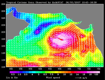
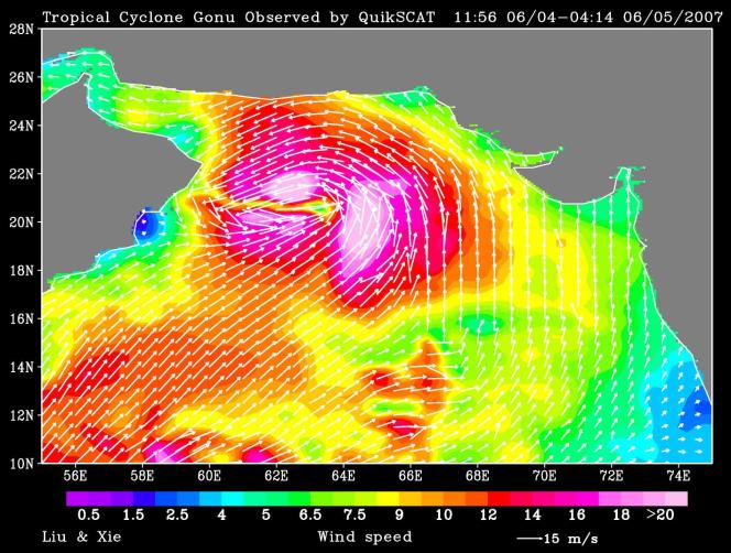
June 3QuikScat observed a rare tropical cyclone in the northern part of the Arabian Sea, threatening the petroleum shipping lanes and the Gulf States (e.g. Oman) that are unprepared for such an event. This is the strongest cyclone to hit the Arabian Peninsula since record keeping started in 1945. The storm reached super-cyclone strength when observed by QuikScat. It weakened as it approached landfall, probably because of the intrusion of dry desert air into the storm.
In the images for June 3 and June 5 produced from QuikScat data, white arrows showing wind direction are superimposed on the color images of wind speed.
QuikScat, managed by JPL, measures ocean surface wind/stress by sending radar pulses to the surface and measuring the strength of the signals returned.
QuikScat Background
NASA's Quick Scatterometer (QuikScat) spacecraft was launched from Vandenberg Air Force Base, Calif., on June 19, 1999. QuikScat carries the SeaWinds scatterometer, a specialized microwave radar that measures near-surface wind speed and direction under all weather and cloud conditions over the Earth's oceans. More information about the QuikScat mission and observations is available at http://winds.jpl.nasa.gov/missions/quikscat/. QuikScat is managed for NASA's Science Mission Directorate, Washington, D.C., by NASA's Jet Propulsion Laboratory, Pasadena, Calif.
