Figure 1
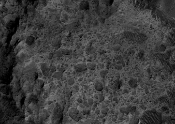
Click on image for larger versionThis HiRISE image covers the southwest portion of the terraces and floor of Holden Crater situated in southwest Margaritifer Terra. The HiRISE sub-frame (figure 1) shows the most clearly-evident image of a megabreccia on Mars. Breccia is a rock typically consisting of rock fragments of various sizes and shapes that have been broken, tumbled and cemented together in sudden geologic event (e.g., a landslide, a flashflood or even an impact-cratering event). If it were not for the dark sandy dunes dispersed through out the sub-image, this image could easily fool an expert into thinking that this image is actually a photograph of a hand sample of an impact breccia. The prefix "mega" implies that the breccia in the sub-image consists of clasts, or rock fragments, that are typically larger than a large house or a building. The rectangular megaclast near the center of the image is a colossal 50 x 25 meters (~150 X 75 feet). As mentioned in the transition image caption for Holden crater (TRA_000861_1530), the crater likely experienced extensive modification by running water, which is supported by observations of drainage and deposition into the crater from a large channel (Uzboi Valles) breaching Holden's southwest rim. While it is possible that the megabreccia formed from a catastrophic release of water into the crater, a more likely possibility is that it formed from the impact that created the approx. 150 km-in-diameter Holden crater. Popigai Crater, a terrestrial crater of half the size of Holden, possesses a similar occurrence of megabreccia with a similar range in megaclast size to the Holden crater example. An impact-generated megabreccia deposit, as observed in terrestrial craters, typically lies beneath the crater floor, so the exhumation of the megabreccia may be the result of down-cutting and erosion of water that once flowed through Uzboi Valles.
Image PSP_001666_1530 was taken by the High Resolution Imaging Science Experiment (HiRISE) camera onboard the Mars Reconnaissance Orbiter spacecraft on December 4, 2006. The complete image is centered at -26.8 degrees latitude, 325.3 degrees East longitude. The range to the target site was 260.1 km (162.6 miles). At this distance the image scale is 26.0 cm/pixel (with 1 x 1 binning) so objects ~78 cm across are resolved. The image shown here [below] has been map-projected to 25 cm/pixel and north is up. The image was taken at a local Mars time of 3:41 PM and the scene is illuminated from the west with a solar incidence angle of 68 degrees, thus the sun was about 22 degrees above the horizon. At a solar longitude of 145.1 degrees, the season on Mars is Northern Summer.
NASA's Jet Propulsion Laboratory, a division of the California Institute of Technology in Pasadena, manages the Mars Reconnaissance Orbiter for NASA's Science Mission Directorate, Washington. Lockheed Martin Space Systems, Denver, is the prime contractor for the project and built the spacecraft. The High Resolution Imaging Science Experiment is operated by the University of Arizona, Tucson, and the instrument was built by Ball Aerospace and Technology Corp., Boulder, Colo.

