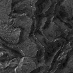
Click on image for larger versionMaterial that has collected within Spallanzani Crater since the impact is now eroding. The erosion has produced a pronounced stair-step pattern, exemplified in this southeast portion of the complete image. Broad flat areas, or plateaus, drop off abruptly down a steep slope to the next relatively flat area, and so on. This pattern suggests discreet boundaries between layers, or stair-steps, of different composition, or time of deposition, or both. The surface texture of the flat areas is similar in most places, characterized by a uniform tone, ripples that may be small dunes (~6 m across), thin furrows, and faint polygons (~20 m across), although dark spots (~8 m across) are concentrated more in some areas and less in others. Near the edge of the plateau area the polygonal fracturing pattern becomes more pronounced. Right at the edge, polygonal plates of surface material are tilted, with the higher end towards the plateau and the lower end being dropped down the slope. These plates are highlighted along plateau edges because they catch the sun better than a flat surface does. The slopes appear to be made up of debris falling from the plateau edge which in some areas includes plates or blocks that have slid part way down from the edge without breaking up. This suggests that plateau surfaces are stronger than the underlying material making up the bulk of the thickness of a single "layer," like a hard crust on a thicker yet softer material. It may be that while this crust protects the underlying material on plateau surfaces, the underlying material is being removed from the side slope where it is not protected (by unknown processes, possibly wind erosion). This process may result in the observed landscape as the underlying material erodes backwards into the plateau and the resistant surface is undercut, breaks into plates along polygonal fractures, and is dropped down, eventually also eroding. The material itself may be loosely held-together sediment covered by a more cemented surface layer, or it may be ice-rich material protected from sublimation from above by a more dust-rich layer.
Image PSP_001345_1215 was taken by the High Resolution Imaging Science Experiment (HiRISE) camera onboard the Mars Reconnaissance Orbiter spacecraft on November 9, 2006. The complete image is centered at -58.0 degrees latitude, 86.5 degrees East longitude. The range to the target site was 248.3 km (155.2 miles). At this distance the image scale is 99.3 cm/pixel (with 4 x 4 binning) so objects ~298 cm across are resolved. The image shown here has been map-projected to 100 cm/pixel and north is up. The image was taken at a local Mars time of 3:47 PM and the scene is illuminated from the west with a solar incidence angle of 89 degrees, thus the sun was about 1 degrees above the horizon. At a solar longitude of 132.7 degrees, the season on Mars is Northern Summer.
NASA's Jet Propulsion Laboratory, a division of the California Institute of Technology in Pasadena, manages the Mars Reconnaissance Orbiter for NASA's Science Mission Directorate, Washington. Lockheed Martin Space Systems, Denver, is the prime contractor for the project and built the spacecraft. The High Resolution Imaging Science Experiment is operated by the University of Arizona, Tucson, and the instrument was built by Ball Aerospace and Technology Corp., Boulder, Colo.

