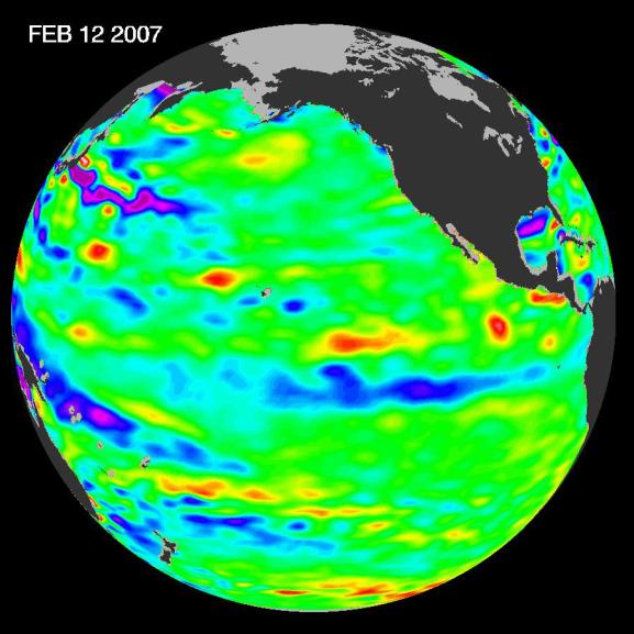
New data of sea-level heights from early February, 2007, by the Jason altimetric satellite show that the tropical Pacific Ocean has transitioned from a warm (El Niþo) to a cool (La Niþa) condition during the prior two months. The beginnings of a possible La Niþa are indicated by the blue area (in the center of the image along the equator) of lower than normal sea level (cold water). It is not certain yet if this current cooling trend will eventually evolve into a long-lasting, well-developed La Niþa.
"La Niþa could send an already parched Western United States to its knees," said JPL oceanographer Dr. Bill Patzert. "In the Southwest, we call La Niþa the little lady with the big dry punch."
A La Niþa situation often follows an El Niþo episode and is essentially the opposite of an El Niþo condition. During a La Nina, trade winds are stronger than normal, and the cold water that normally exists along the coast of South America extends to the central equatorial Pacific. A La Niþa situation changes global weather patterns and is associated with less moisture in the air, resulting in less rain along the coasts of North and South America. Jason will continue to track this developing switch in the climate.
This image of the Pacific Ocean was produced using sea-surface height measurements taken by the U.S.-French Jason satellite. The image is based on the average of 10 days of data centered on February 12, 2007, compared to the long-term average of observations from 1993 through 2005. In this image, places where the Pacific sea surface height is higher (warmer) than normal are yellow and red, and places where the sea surface is lower (cooler) than normal are blue and purple. Green shows where conditions are near normal. Sea-surface height is an indicator of the heat content of the upper ocean.
NASA's Jet Propulsion Laboratory manages the U.S. portion of the U.S./French Jason mission for NASA's Science Mission Directorate, Washington, D.C. JPL is a division of the California Institute of Technology, Pasadena, Calif.
For more information on NASA's ocean surface topography missions, see http://sealevel.jpl.nasa.gov/ or to view the latest Jason data see http://sealevel.jpl.nasa.gov/science/jason1-quick-look/.