NASA's Mars Pathfinder landed on Mars on July 4, 1997, and continued operating until Sept. 27 of that year. The landing site is on an ancient flood plain of the Ares and Tiu outflow channels. The High Resolution Imaging Science Experiment (HiRISE) camera on NASA's Mars Reconnaissance Orbiter took an image on Dec. 21, 2006, that provides unprecedented detail of the geology of the region and hardware on the surface.
HiRISE Image
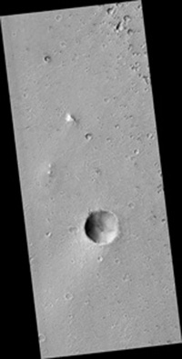
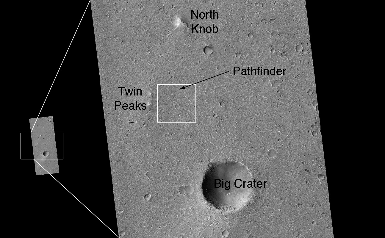
This is the entire image. The crater at center bottom was unofficially named "Big Crater" by the Pathfinder team. Its wall was visible from Pathfinder, located 3 kilometers (2 miles) to the north. The two bright features to the upper left of Big Crater are the "Twin Peaks," also observed by Pathfinder. The bright mound to the upper right of the Twin Peaks is "North Knob," seen in Pathfinder images as peaking over the horizon.
At this scale there is no obvious geologic evidence of an ancient flood. Rather, impact craters dominate the scene, attesting to an old surface. The age is probably on the order of 1.8 billion to 3.5 billion years, when the Ares and Tiu floods are estimated to have occurred. Wind-formed linear ripples and dunes are seen throughout and are concentrated within craters. Sets of polygonal ridges of enigmatic origin are seen east of the Pathfinder lander. Rocks are visible over the entire image, with heavy concentrations near fresh-looking craters. Most of them are probably blocks tossed outward by crater-forming impacts.
The complete image is centered at 19.1 degrees north latitude, 326.8 degrees east longitude. The range to the target site was 284.7 kilometers (177.9 miles). At this distance the image scale is 28.5 centimeters (11 inches) per pixel, so objects about 85 centimeters (33 inches) across are resolved. The image shown here has been map-projected to 25 centimeters (10 inches) per pixel. North is up. The image was taken at a local Mars time of 3:35 p.m., and the scene is illuminated from the west with a solar incidence angle of 52 degrees, thus the sun was about 38 degrees above the horizon. At a solar longitude of 154.0 degrees, the season on Mars is northern summer.
Landing Site Region
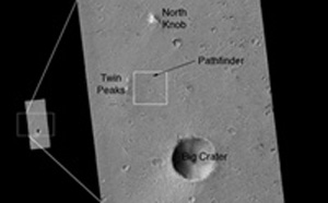
This is a close-up of the area in the vicinity of the Pathfinder landing site. Major features are named. The white box outlines the area of the image, discussed next, where hardware is seen.
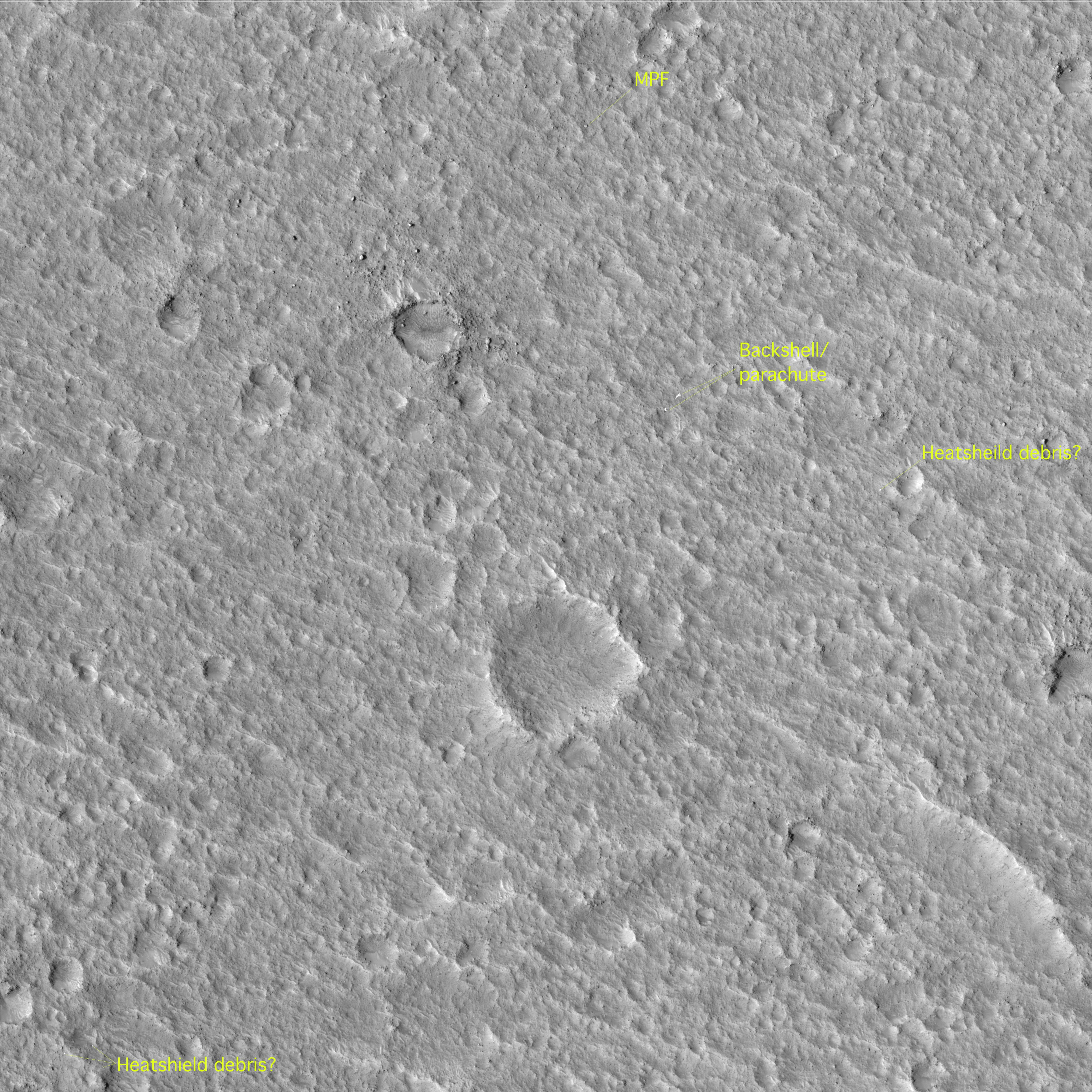
Hardware on the Surface
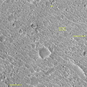
This image shows the Pathfinder lander on the surface. Zooming in, one can discern the ramps, science deck, and portions of the airbags on the Pathfinder lander. (See next image for closer view.) The back shell and parachute are to the south, and four features that may be portions of the heat shield are identified. Two of these were visible from Pathfinder. At the time of that mission, the nearest object was provisionally identified as the back shell. However, analysis of the HiRISE image and reinterpretation of Pathfinder images, plus an improved understanding of how hardware looks on the Martian surface based on ground-level and orbital images of the Mars Exploration Rover landing sites, indicate that the glint is bright enough that it may be insulating material from inside the heat shield. The back shell and parachute were out of sight behind a ridge from Pathfinder's ground view. One of the three bright features, identified as heat shield debris, was also identified during the Pathfinder mission.
 |  |
| Annotated Version | Unannotated Version | |
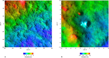
Topographic Map of Landing Site Region
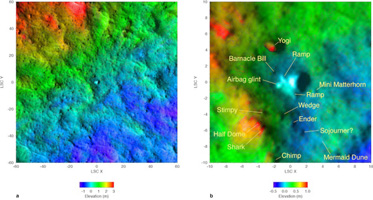
Portions of the HiRISE image are overlaid onto color-coded topographic maps constructed by the U.S. Geological Survey from stereo images acquired by the Imager for Mars Pathfinder on the lander. The white feature at the center is Pathfinder lander. The scales on the x and y axes are in meters, with the lander as the zero point. The color code for elevation relative to the lander is different in the left and right images, and shown in meters underneath each image. The correspondence between the overhead view revealed by HiRISE and the positions of topographic features inferred almost a decade ago from Pathfinder's horizontal view of the landscape is striking. The close-up on the right complements panoramas taken by the lander's camera, including the accompanying composite version showing the Sojourner rover at various locations it reached during the mission.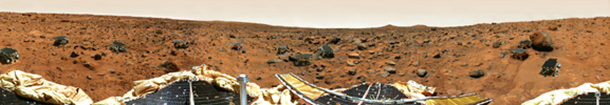
Mars Pathfinder Gallery Panorama
This version of the Gallery Panorama taken with the lander's Imager for Mars Pathfinder camera shows many of the locations where the mission's Sojourner rover ended a Martian day during the 12-week mission. (There was only one Sojourner. The image is a composite.) One annotation indicates the last known position of Sojourner, near the rock "Chimp," at the time of the final data transmission from the lander. The location labeled "Sojourner?" has been tentatively identified as the current position of the rover based on comparison of the ground-level view with the Dec. 21, 2006, image from NASA's Mars Reconnaissance Orbiter. At the proposed current location of the rover, a feature can be discerned in the 2006 orbital image that is about the right size for Sojourner and wasn't present when the Gallery Panorama was taken. Some rocks and other features that can be identified in the orbiter's high-resolution view are labeled in this ground-level view.
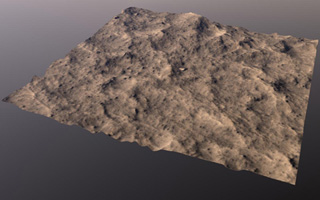
Topographic Perspective of Landing Site Region)
This is a perspective view based on the topographic map and artificial color derived from Pathfinder and other data. The vertical scale is exaggerated by a factor of three, compared with horizontal dimensions. The white feature at center is the Pathfinder lander. It appears flat because the topographic map derived from the Imager for Mars Pathfinder data did not include the spacecraft itself.
 Planetary Data System


