Has liquid water flowed on Mars in this decade? In June 2000, we reported the discovery, using the Mars Global Surveyor's Mars Orbiter Camera, of very youthful-looking gullies found on slopes at middle and high latitudes on Mars. Since that time, tens of thousands of gullies have been imaged by all of the Mars orbiting spacecraft: Mars Global Surveyor, Mars Odyssey, Mars Express and Mars Reconnaissance Orbiter.
During the years since the original June 2000 report, the Mars Global Surveyor's camera was used to test the hypothesis that the gullies may be so young that some of them could still be active today. The test was very simple: re-image gullies previously seen by the camera and see if anything has changed.
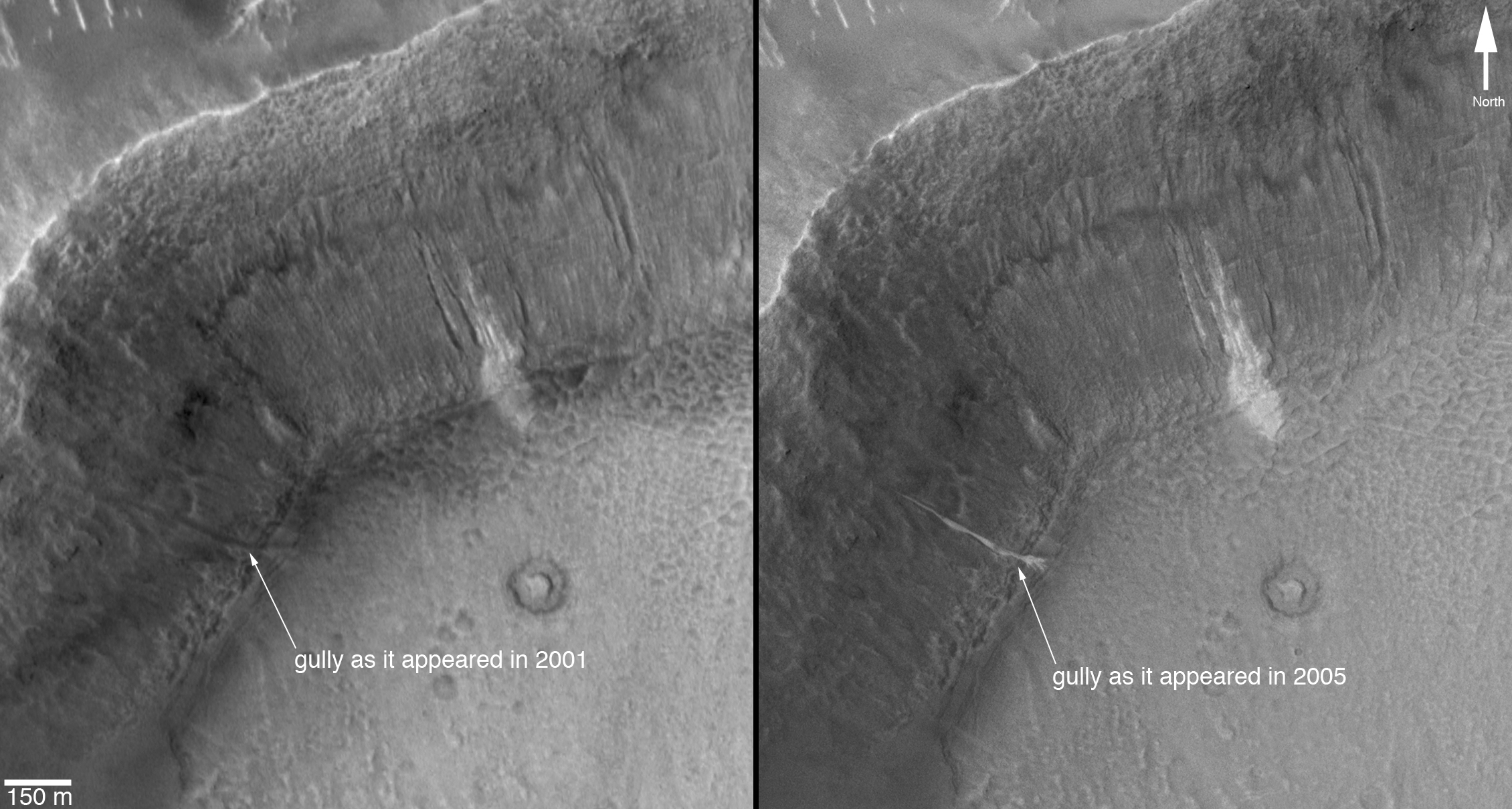
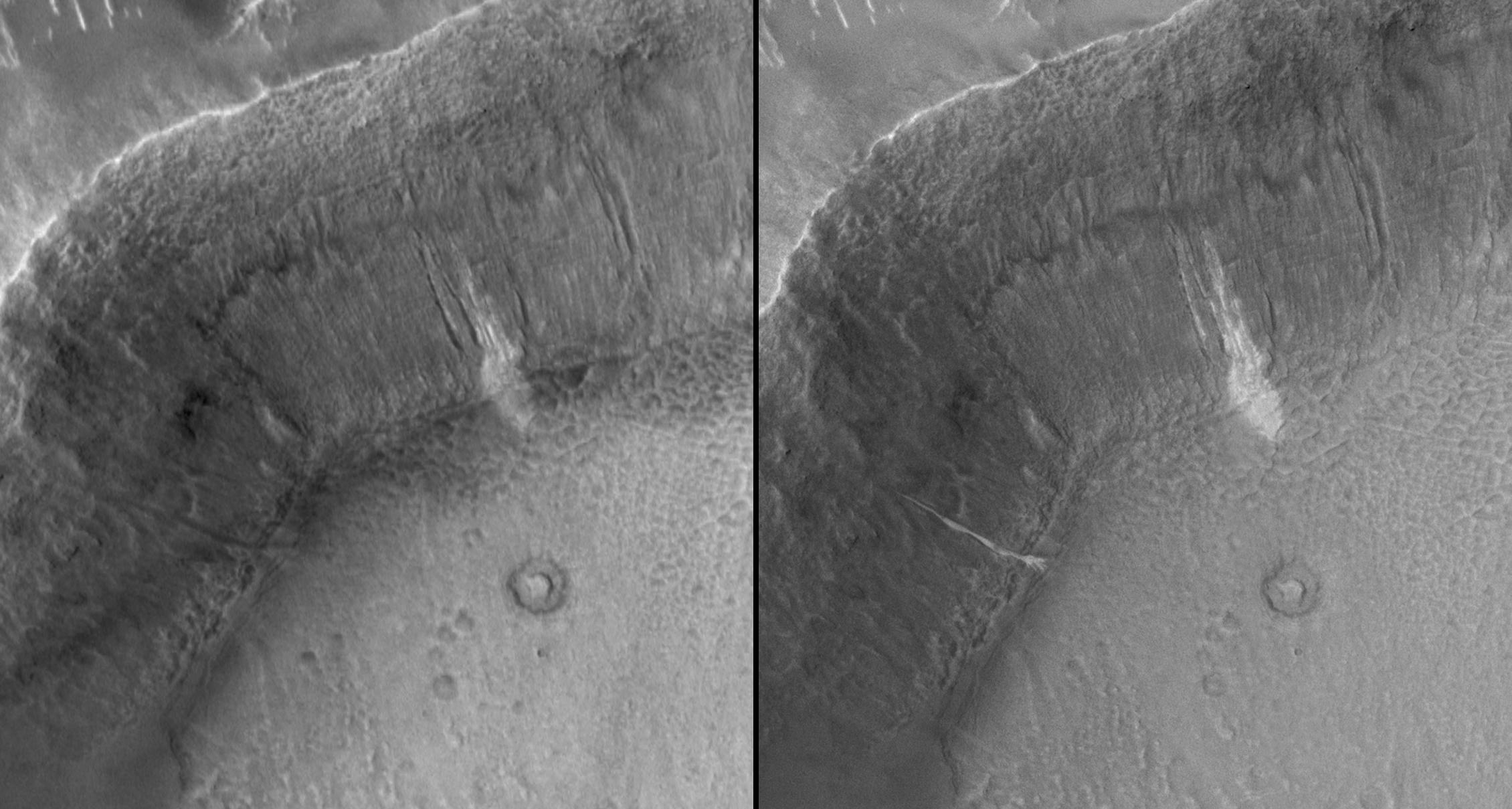
In two cases, something changed. One of those cases is presented here. A gully on the wall of an unnamed crater in Terra Sirenum, at 36.6 degrees south, 161.8 degrees west, was initially imaged by the camera on Dec. 22, 2001 (Figure A, left). It showed nothing noteworthy at the location where a change would later be observed, but a group of nearby gullies exhibited an unusual patch of light-toned material. As part of our routine campaign to re-image gully sites using the camera, another image of this location was acquired on April 24, 2005. A new light-toned deposit had appeared in what was otherwise a nondescript gully (Figure A, right). This deposit was imaged again by the camera on Aug. 26, 2005, at a time when the sun angle and season were the same as in the original December 2001 image, to confirm that indeed the light-toned feature was something new, not just a trick of differing lighting conditions. In August 2005, the feature was still present.
Figure A: This set of images shows a comparison of the gully site as it appeared on Dec. 22, 2001 (left), with a mosaic of two images acquired after the change occurred (the two images are from Aug. 26, 2005, and Sept. 25, 2005). Sunlight illuminates each scene from the northwest (top left). The 150-meter scale bar represents 164 yards.
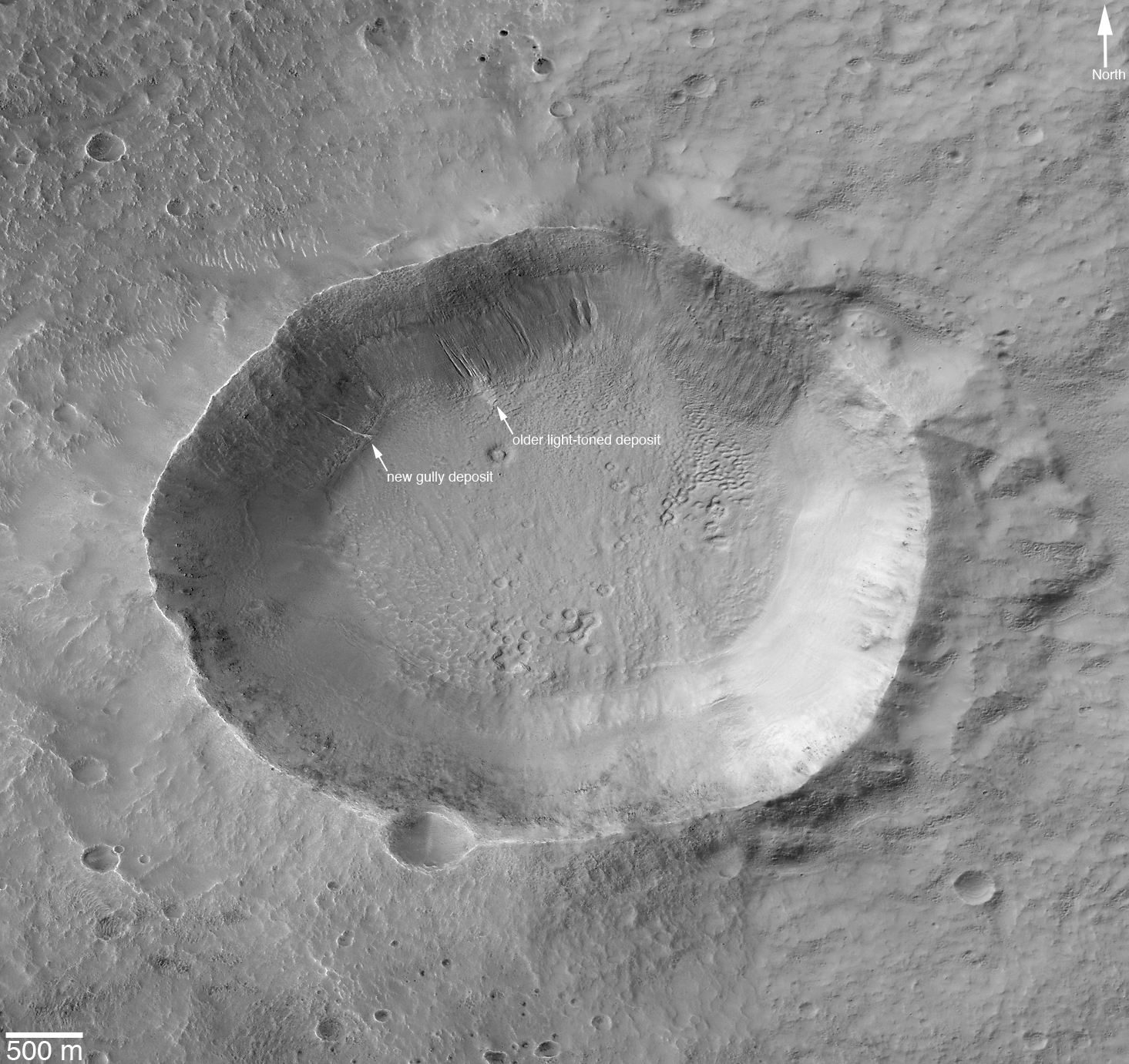
Figure B: This is a mosaic of images that cover the entire unnamed crater in Terra Sirenum. The location of the light-toned gully deposits, old and new, is indicated. This is a mosaic of images acquired by the camera in 2005 and 2006. The 500-meter scale bar equals approximately 547 yards.
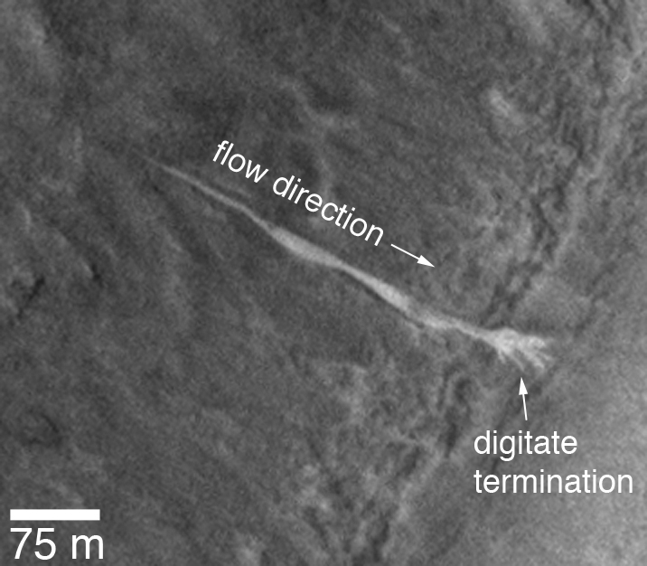
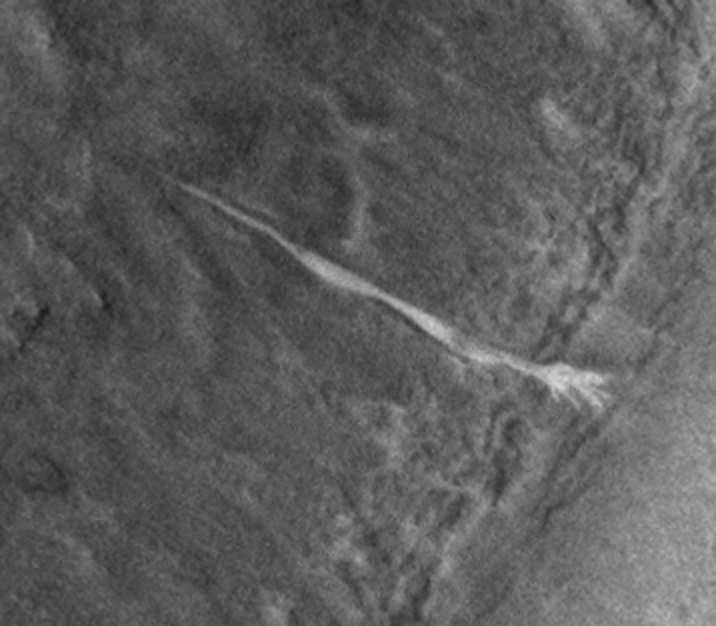
Figure C: This image shows an enlargement of a portion of another image from August 2005, showing details of the new, light-toned gully deposit. The new material covers the entire gully floor, from the point at which the gully emerged from beneath a mantled slope, down to the spot at which the channel meets the crater floor. At this break in slope, the gully material, as it was emplaced, spread out into five or six different fingers (this is called a "digitate" termination as in finger digits). The 75-meter scale bar represents a distance of about 82 yards.
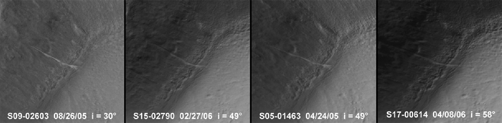
Figure D: To confirm that the new, light-toned gully deposit is not just a trick of changing illumination conditions as the sun rises to different levels in the sky each season, the Mars Orbiter Camera team repeatedly imaged this site throughout 2005 and 2006. Four examples are shown here, acquired in April 2005, August 2005, February 2006 and April 2006. The "i=" indicates solar-incidence angle, or the height of the sun in the local sky, relative to a case where the sun would be directly overhead (i=0 degrees). Thus, the higher the incidence angle, the lower the sun would appear in the sky to an observer on the ground.
These images show that a material flowed down through a gully channel, once between December 2001 and April 2005. After the flow stopped, it left behind evidence -- the light-toned deposit. The deposit is thin enough that its thickness cannot be measured in the camera's 1.5-meters-per-pixel images. However, it does exhibit a digitate termination, suggesting that the material flowed in a fluid-like manner down the approximately 25 degree slope before splaying out into multiple small lobes at the point where the crater wall meets the crater floor and the slope suddenly drops to near zero. This deposit, and a similar one in a crater in the Centauri Montes, together suggests that the materials involved were low-volume debris flows containing a mixture of sediment and a liquid that had the physical properties of liquid water. In this case, we propose that the water came from below the surface, emerged somewhere beneath the mantle covering the original crater wall, and then ran down through a previously existing gully channel. No new gully was formed, but an old one was re-activated.
The light tone of the new gully deposit, and that of the older, neighboring gullies, is intriguing. We cannot know from these images whether the light tone indicates that ice is still present in and on the surface of the deposit. Indeed, ice may not be likely: under present conditions on the surface of Mars, ice would be expected to have sublimed, or vaporized, away fairly shortly after the new deposit formed. However, the light-toned material could be frost that forms and re-forms frequently as trapped water-ice sublimes and "exhales" from within the deposit. Alternatively, the light-tone may result if the deposit consists of significantly finer grains (for example, fine silt) than the surrounding surfaces, or if the deposit's surface is covered with minerals such as salts formed as water evaporated from the material.
Do these images prove that water has flowed on Mars? No, they cannot. However, they provide the first very tantalizing evidence that this may have occurred. While the surface environment on Mars is extremely dry, drier than the most arid deserts on Earth, liquid water from beneath the Martian surface may have come out of the ground and flowed across this little portion of the red planet in this decade.
The Mars Global Surveyor mission is managed for NASA's Office of Space Science, Washington, by NASA's Jet Propulsion Laboratory, Pasadena, Calif., a division of the California Institute of Technology, also in Pasadena. Lockheed Martin Space Systems, Denver, developed and operates the spacecraft. Malin Space Science Systems, San Diego, Calif., built and operates the Mars Orbiter Camera.
For more information about images from the Mars Orbiter Camera, see http://www.msss.com/mgs/moc/index.html.
 Planetary Data System


