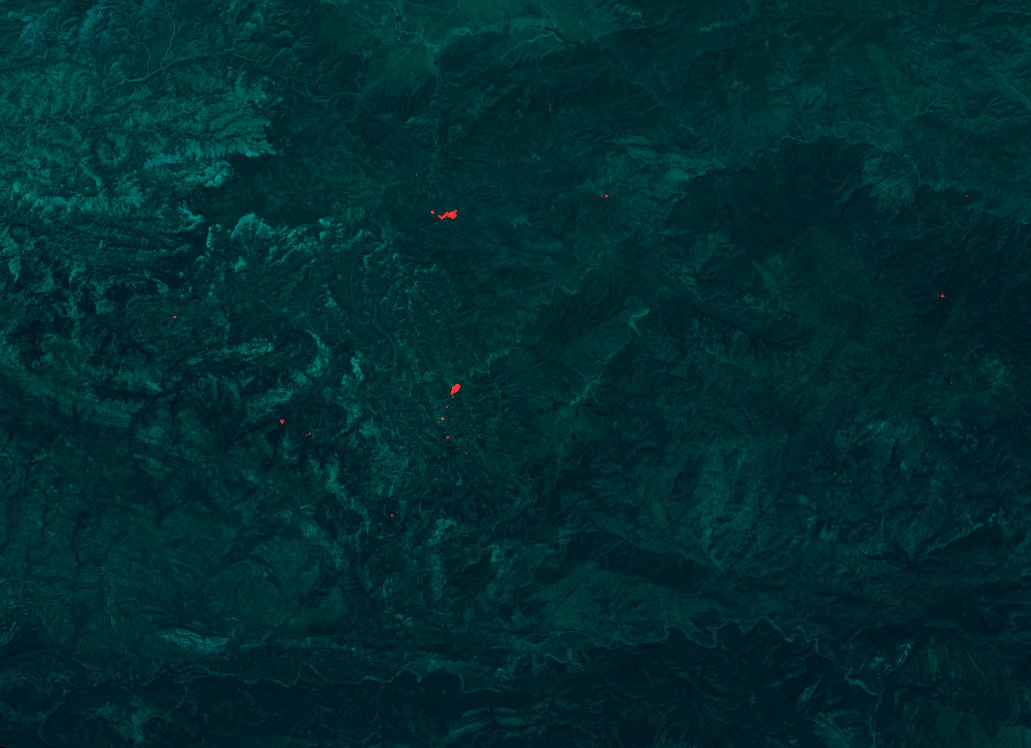
Annotated VersionThe Day fire has been burning in Ventura County in Southern California since Labor Day, and has consumed more than 160,000 acres. As of September 29, it was 63 percent contained. The Advanced Spaceborne Thermal Emission and Reflection Radiometer on NASA's Terra satellite flew over the fire at 10 p.m. Pacific Time on September 28, and imaged the fire with its infrared camera. The hottest areas of active burning appear as red spots on the image. The blue-green background is a daytime image acquired in June, used as a background to allow firefighters to localize the hot spots.
With its 14 spectral bands from the visible to the thermal infrared wavelength region, and its high spatial resolution of 15 to 90 meters (about 50 to 300 feet), ASTER images Earth to map and monitor the changing surface of our planet.
ASTER is one of five Earth-observing instruments launched December 18, 1999, on NASA's Terra satellite. The instrument was built by Japan's Ministry of Economy, Trade and Industry. A joint U.S./Japan science team is responsible for validation and calibration of the instrument and the data products.
The broad spectral coverage and high spectral resolution of ASTER provides scientists in numerous disciplines with critical information for surface mapping, and monitoring of dynamic conditions and temporal change. Example applications are: monitoring glacial advances and retreats; monitoring potentially active volcanoes; identifying crop stress; determining cloud morphology and physical properties; wetlands evaluation; thermal pollution monitoring; coral reef degradation; surface temperature mapping of soils and geology; and measuring surface heat balance.
The U.S. science team is located at NASA's Jet Propulsion Laboratory, Pasadena, Calif. The Terra mission is part of NASA's Science Mission directorate.
Size: 22.5 by 31.0 kilometers (12.6 by 15.2 miles)
Location: 34.6 degrees North latitude, 119.1 degrees West longitude
Orientation: North at top
Image Data: ASTER Bands 4, 2, and 1 Original Data Resolution: ASTER 15 meters (49.2 feet) and 30 meters (98.4 feet)
Dates Acquired: September 28, 2006 and June 19 2006

