PDS logoPlanetary Data System
PDS Information
Find a Node - Use these links to navigate to any of the 8 publicly accessible PDS Nodes.

This bar indicates that you are within the PDS enterprise which includes 6 science discipline nodes and 2 support nodes which are overseen by the Project Management Office at NASA's Goddard Space Flight Center (GSFC). Each node is led by an expert in the subject discipline, supported by an advisory group of other practitioners of that discipline, and subject to selection and approval under a regular NASA Research Announcement.
Click here to return to the Photojournal Home Page Click here to view a list of Photojournal Image Galleries Photojournal_inner_header
Latest Images  |  Spacecraft & Technology  |  Animations  |  Space Images App  |  Feedback  |  Photojournal Search  

PIA08449: Complex Terrain
 Target Name:  Titan
 Is a satellite of:  Saturn
 Mission:  Cassini-Huygens
 Spacecraft:  Cassini Orbiter
 Instrument:  Radar Mapper
 Product Size:  1191 x 1163 pixels (w x h)
 Produced By:  JPL
 Full-Res TIFF:  PIA08449.tif (1.387 MB)
 Full-Res JPEG:  PIA08449.jpg (518 kB)

Click on the image above to download a moderately sized image in JPEG format (possibly reduced in size from original)

Original Caption Released with Image:

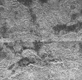
This complex area of hilly terrain and erosional channels is located atop Xanadu, the continent-sized region on Saturn's moon Titan. The image was captured by the Cassini Titan Radar Mapper on April 30, 2006. It shows details as small as 350 meters (1148 feet). Each side of the picture covers 200 kilometers (124 miles).

Chains of hills or mountains are located near the bottom of the image, appearing bright on their north side (toward the top in this image). Extending further north is a drainage region where liquids flowed, eroding the presumably water-ice bedrock of Xanadu. Careful inspection reveals a series of faint drainage channels, some of which appear to empty into the dark region near the top of the image. Liquid methane might be fed from springs within Xanadu or by occasional rainfall suspected to occur on Titan. There is evidence for this rainfall in images taken by the Descent Imager/Spectral Radiometer camera on the Huygens probe as it landed, well to the west of this area, on January 14, 2005 (see PIA07238).

The Cassini-Huygens mission is a cooperative project of NASA, the European Space Agency and the Italian Space Agency. The Jet Propulsion Laboratory, a division of the California Institute of Technology in Pasadena, manages the mission for NASA's Science Mission Directorate, Washington, D.C. The Cassini orbiter was designed, developed and assembled at JPL. The radar instrument was built by JPL and the Italian Space Agency, working with team members from the United States and several European countries.

For more information about the Cassini-Huygens mission visit http://saturn.jpl.nasa.gov/home/index.cfm.

Image Credit:
NASA/JPL-Caltech/ASI

Image Addition Date:
2006-05-09