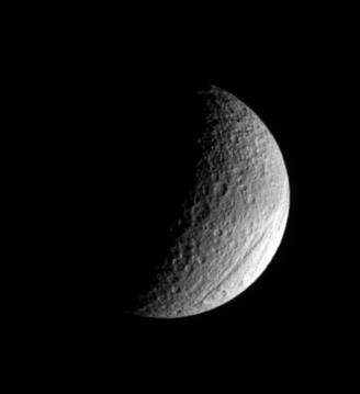
The ancient gorge of Ithaca Chasma carves a path across Tethys and continues out of sight over the moon's limb. This great rift is a system of canyons that is 100 kilometers (60 miles) across on average, is 4 kilometers (2 miles) deep in places, and can be traced more than 1,000 kilometers (620 miles) over Tethys' surface, from north to south.
This view also shows the belt of darkened material that Tethys (1,071 kilometers, or 665 miles across) wears prominently on its leading hemisphere. North is up.
The image was taken in visible light with the Cassini spacecraft narrow-angle camera on July 23, 2006 at a distance of approximately 795,000 kilometers (494,000 miles) from Tethys and at a Sun-Tethys-spacecraft, or phase, angle of 99 degrees. Image scale is 5 kilometers (3 miles) per pixel.
The Cassini-Huygens mission is a cooperative project of NASA, the European Space Agency and the Italian Space Agency. The Jet Propulsion Laboratory, a division of the California Institute of Technology in Pasadena, manages the mission for NASA's Science Mission Directorate, Washington, D.C. The Cassini orbiter and its two onboard cameras were designed, developed and assembled at JPL. The imaging operations center is based at the Space Science Institute in Boulder, Colo.
For more information about the Cassini-Huygens mission visit http://saturn.jpl.nasa.gov/home/index.cfm. The Cassini imaging team homepage is at http://ciclops.org.