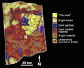
Geologic Map of Titan VolcanoFrom infrared images that show variations in brightness and texture, a geological map of the circular feature, thought to be a volcano, has been obtained using Cassini's visual and infrared mapping spectrometer.
This geologic map shows that the circular feature has what appear to be several series of flows, as shown by the black lines. The flows represent episodes of activity on the volcano. A dark central pit, called a caldera, is similar to vents that appear above reservoirs of molten material on Earth's volcanoes.
The colors on the map represent the brightness of features. Yellow and light green represent bright patches. Blue represents dark patches. Red represents mottled material. The yellow area is where the volcano lies.
These images were taken during Cassini's Oct. 26, 2004, flyby of Titan.
The Cassini-Huygens mission is a cooperative project of NASA, the European Space Agency and the Italian Space Agency. The Jet Propulsion Laboratory, a division of the California Institute of Technology in Pasadena, manages the mission for NASA's Science Mission Directorate, Washington, D.C. The Cassini orbiter and its two onboard cameras were designed, developed and assembled at JPL. The visual and infrared mapping spectrometer team is based at the University of Arizona.
For more information about the Cassini-Huygens mission visit http://saturn.jpl.nasa.gov. The visual and infrared mapping spectrometer team homepage is at http://wwwvims.lpl.arizona.edu.

