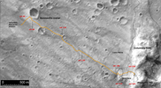
Figure 1: Spirit's Long Journey, Sol 450This view from orbit shows the region within Gusev Crater where NASA's Mars Exploration Rover Spirit has been working for the past 15 months. The view is a mosaic of images from the Mars Orbiter Camera on NASA's Mars Global Surveyor orbiter. In the left and central portion, previously released as PIA07192, tracks made by Spirit's wheels are visible from the landing site to the edge of the "Columbia Hills."
Spirit's Long Journey, Sol 450 (Full Traverse)
More than 15 months after landing on Mars, NASA's Spirit rover is still going strong, having traveled a total of 4,276 meters (2.66 miles) as of martian day, or sol, 450 (April 8, 2005). This elevation map shows the traverse followed by Spirit since arriving at the "Columbia Hills" in June, 2004. The areas colored blue are low in elevation and areas colored yellow are high in elevation. The blue area at the foot of the "Columbia Hills" is approximately 20 meters (66 feet) higher in elevation than the site where Spirit landed in Gusev Crater. The highest peak is on the order of 80 meters (262 feet) higher still. In other words, the hills Spirit is exploring are more than 250 feet high. The map imagery is from the Mars Orbiter Camera on NASA's Mars Global Surveyor.
